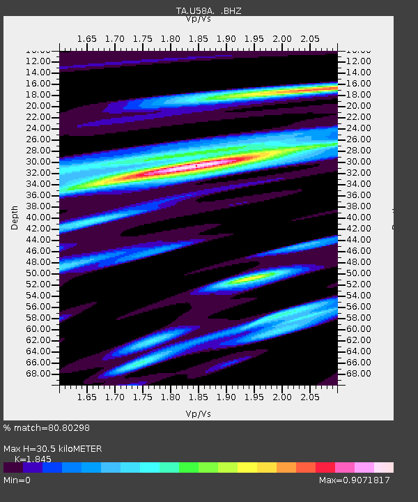
U58A Oxford, NC, USA - Earthquake Result Viewer
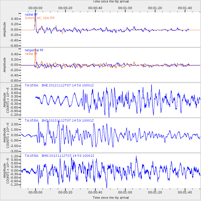
Earthquake location: Near East Coast Of Kamchatka
Earthquake latitude/longitude: 54.7/162.3
Earthquake time(UTC): 2013/11/12 (316) 07:03:51 GMT
Earthquake Depth: 43 km
Earthquake Magnitude: 6.4 MWW, 6.3 MWC, 6.4 MWW, 6.4 MWB, 6.5 MWC, 6.6 MI
Earthquake Catalog/Contributor: NEIC PDE/NEIC COMCAT
Network: TA USArray Transportable Network (new EarthScope stations)
Station: U58A Oxford, NC, USA
Lat/Lon: 36.39 N/78.55 W
Elevation: 169 m
Distance: 75.4 deg
Az: 46.746 deg
Baz: 328.39 deg
Ray Param: 0.051648833
Estimated Moho Depth: 30.5 km
Estimated Crust Vp/Vs: 1.85
Assumed Crust Vp: 6.419 km/s
Estimated Crust Vs: 3.479 km/s
Estimated Crust Poisson's Ratio: 0.29
Radial Match: 80.80298 %
Radial Bump: 381
Transverse Match: 74.75737 %
Transverse Bump: 400
SOD ConfigId: 626651
Insert Time: 2014-04-19 13:57:57.604 +0000
GWidth: 2.5
Max Bumps: 400
Tol: 0.001

Signal To Noise

ChannelStoNSTALTA
TA:U58A: :BHZ:20131112T07:14:59.10001Z2.81635387.910202E-72.8086677E-7
TA:U58A: :BHN:20131112T07:14:59.10001Z1.50521833.860418E-72.5646898E-7
TA:U58A: :BHE:20131112T07:14:59.10001Z1.47782153.8409158E-72.599039E-7
Arrivals
Ps4.1 SECOND
PpPs13 SECOND
PsPs/PpSs17 SECOND