W61A Ground Anchor Farm, New Bern, NC, USA - Earthquake Result Viewer
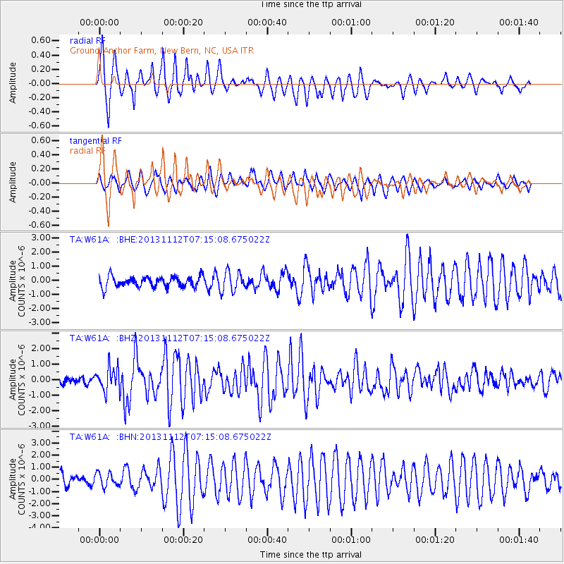
Earthquake location: Near East Coast Of Kamchatka
Earthquake latitude/longitude: 54.7/162.3
Earthquake time(UTC): 2013/11/12 (316) 07:03:51 GMT
Earthquake Depth: 43 km
Earthquake Magnitude: 6.4 MWW, 6.3 MWC, 6.4 MWW, 6.4 MWB, 6.5 MWC, 6.6 MI
Earthquake Catalog/Contributor: NEIC PDE/NEIC COMCAT
Network: TA USArray Transportable Network (new EarthScope stations)
Station: W61A Ground Anchor Farm, New Bern, NC, USA
Lat/Lon: 35.18 N/76.99 W
Elevation: 6.0 m
Distance: 77.1 deg
Az: 46.278 deg
Baz: 329.186 deg
Ray Param: 0.050510153
Estimated Moho Depth: 39.75 km
Estimated Crust Vp/Vs: 1.60
Assumed Crust Vp: 6.565 km/s
Estimated Crust Vs: 4.096 km/s
Estimated Crust Poisson's Ratio: 0.18
Radial Match: 90.371376 %
Radial Bump: 384
Transverse Match: 74.09244 %
Transverse Bump: 400
SOD ConfigId: 626651
Insert Time: 2014-04-19 13:59:13.945 +0000
GWidth: 2.5
Max Bumps: 400
Tol: 0.001

Signal To Noise

ChannelStoNSTALTA
TA:W61A: :BHZ:20131112T07:15:08.675022Z3.54212767.7968133E-72.2011668E-7
TA:W61A: :BHN:20131112T07:15:08.675022Z0.96452355.6441206E-75.8517196E-7
TA:W61A: :BHE:20131112T07:15:08.675022Z1.84544777.0608E-73.8260637E-7
Arrivals
Ps3.8 SECOND
PpPs15 SECOND
PsPs/PpSs19 SECOND