You are here: Home > Network List > US - United States National Seismic Network Stations List
> Station HAWA Hanford, Washington, USA > Earthquake Result Viewer
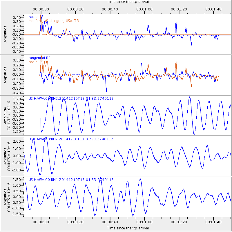
HAWA Hanford, Washington, USA - Earthquake Result Viewer
*The percent match for this event was below the threshold and hence no stack was calculated.
| Earthquake location: |
Tonga Islands |
| Earthquake latitude/longitude: |
-18.5/-173.1 |
| Earthquake time(UTC): |
2014/12/10 (344) 12:49:51 GMT |
| Earthquake Depth: |
10 km |
| Earthquake Magnitude: |
5.0 MW, 5.0 mb |
| Earthquake Catalog/Contributor: |
ISC/ISC |
|
| Network: |
US United States National Seismic Network |
| Station: |
HAWA Hanford, Washington, USA |
| Lat/Lon: |
46.39 N/119.53 W |
| Elevation: |
364 m |
|
| Distance: |
80.6 deg |
| Az: |
34.348 deg |
| Baz: |
230.679 deg |
| Ray Param: |
$rayparam |
*The percent match for this event was below the threshold and hence was not used in the summary stack. |
|
| Radial Match: |
55.05116 % |
| Radial Bump: |
400 |
| Transverse Match: |
68.83497 % |
| Transverse Bump: |
400 |
| SOD ConfigId: |
3390531 |
| Insert Time: |
2019-04-15 12:01:12.488 +0000 |
| GWidth: |
2.5 |
| Max Bumps: |
400 |
| Tol: |
0.001 |
|
Signal To Noise
| Channel | StoN | STA | LTA |
| US:HAWA:00:BHZ:20141210T13:01:33.274011Z | 2.1094275 | 1.9566878E-6 | 9.275919E-7 |
| US:HAWA:00:BH1:20141210T13:01:33.274011Z | 0.5253849 | 3.4036614E-7 | 6.478415E-7 |
| US:HAWA:00:BH2:20141210T13:01:33.274011Z | 0.8841535 | 8.026996E-7 | 9.0787364E-7 |
| Arrivals |
| Ps | |
| PpPs | |
| PsPs/PpSs | |


