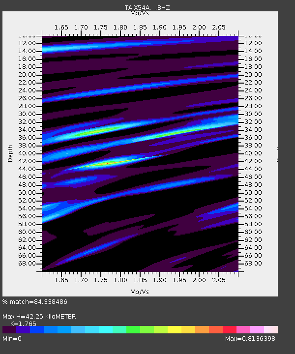
X54A Belton, SC, USA - Earthquake Result Viewer
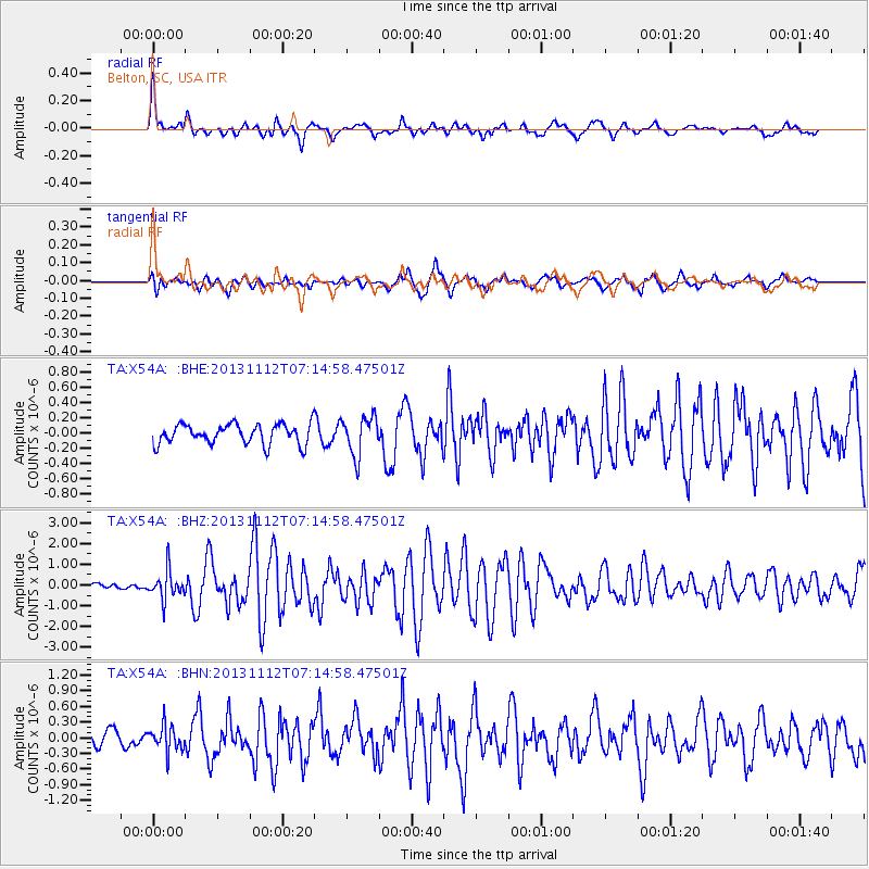
Earthquake location: Near East Coast Of Kamchatka
Earthquake latitude/longitude: 54.7/162.3
Earthquake time(UTC): 2013/11/12 (316) 07:03:51 GMT
Earthquake Depth: 43 km
Earthquake Magnitude: 6.4 MWW, 6.3 MWC, 6.4 MWW, 6.4 MWB, 6.5 MWC, 6.6 MI
Earthquake Catalog/Contributor: NEIC PDE/NEIC COMCAT
Network: TA USArray Transportable Network (new EarthScope stations)
Station: X54A Belton, SC, USA
Lat/Lon: 34.55 N/82.37 W
Elevation: 213 m
Distance: 75.3 deg
Az: 50.492 deg
Baz: 327.13 deg
Ray Param: 0.051721346
Estimated Moho Depth: 42.25 km
Estimated Crust Vp/Vs: 1.76
Assumed Crust Vp: 6.35 km/s
Estimated Crust Vs: 3.598 km/s
Estimated Crust Poisson's Ratio: 0.26
Radial Match: 84.338486 %
Radial Bump: 400
Transverse Match: 79.707214 %
Transverse Bump: 400
SOD ConfigId: 626651
Insert Time: 2014-04-19 13:59:32.688 +0000
GWidth: 2.5
Max Bumps: 400
Tol: 0.001

Signal To Noise

ChannelStoNSTALTA
TA:X54A: :BHZ:20131112T07:14:58.47501Z3.28241446.9568904E-72.119443E-7
TA:X54A: :BHN:20131112T07:14:58.47501Z1.1786812.5024045E-72.123055E-7
TA:X54A: :BHE:20131112T07:14:58.47501Z1.97376742.574132E-71.3041719E-7
Arrivals
Ps5.3 SECOND
PpPs18 SECOND
PsPs/PpSs23 SECOND