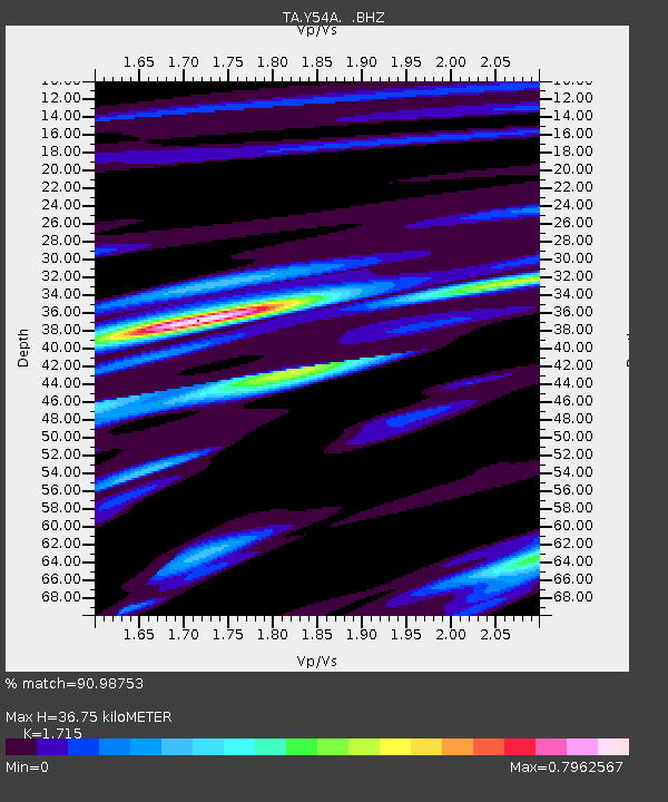
Y54A Tignall, GA, USA - Earthquake Result Viewer
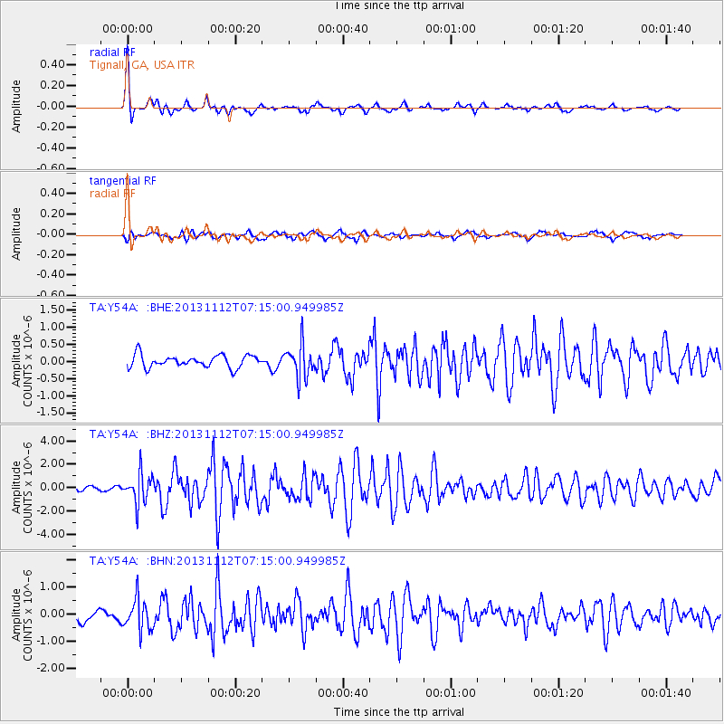
Earthquake location: Near East Coast Of Kamchatka
Earthquake latitude/longitude: 54.7/162.3
Earthquake time(UTC): 2013/11/12 (316) 07:03:51 GMT
Earthquake Depth: 43 km
Earthquake Magnitude: 6.4 MWW, 6.3 MWC, 6.4 MWW, 6.4 MWB, 6.5 MWC, 6.6 MI
Earthquake Catalog/Contributor: NEIC PDE/NEIC COMCAT
Network: TA USArray Transportable Network (new EarthScope stations)
Station: Y54A Tignall, GA, USA
Lat/Lon: 33.86 N/82.69 W
Elevation: 176 m
Distance: 75.7 deg
Az: 51.101 deg
Baz: 327.107 deg
Ray Param: 0.05142919
Estimated Moho Depth: 36.75 km
Estimated Crust Vp/Vs: 1.72
Assumed Crust Vp: 6.565 km/s
Estimated Crust Vs: 3.828 km/s
Estimated Crust Poisson's Ratio: 0.24
Radial Match: 90.98753 %
Radial Bump: 309
Transverse Match: 73.04457 %
Transverse Bump: 400
SOD ConfigId: 626651
Insert Time: 2014-04-19 14:00:01.062 +0000
GWidth: 2.5
Max Bumps: 400
Tol: 0.001

Signal To Noise

ChannelStoNSTALTA
TA:Y54A: :BHZ:20131112T07:15:00.949985Z8.0623481.2800695E-61.587713E-7
TA:Y54A: :BHN:20131112T07:15:00.949985Z2.71070035.7814896E-72.1328398E-7
TA:Y54A: :BHE:20131112T07:15:00.949985Z2.65313774.76176E-71.7947656E-7
Arrivals
Ps4.1 SECOND
PpPs15 SECOND
PsPs/PpSs19 SECOND