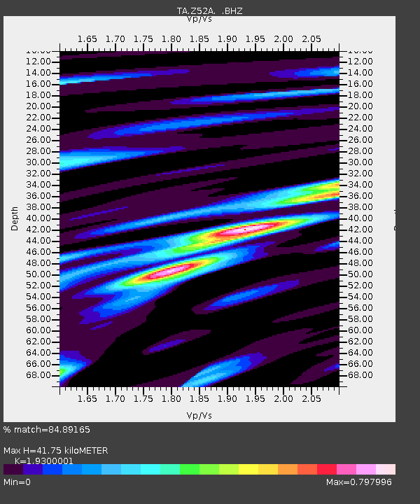
Z52A Williamson, GA, USA - Earthquake Result Viewer
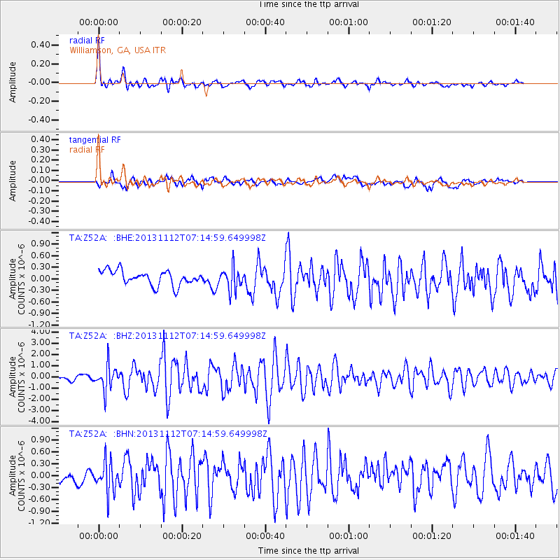
Earthquake location: Near East Coast Of Kamchatka
Earthquake latitude/longitude: 54.7/162.3
Earthquake time(UTC): 2013/11/12 (316) 07:03:51 GMT
Earthquake Depth: 43 km
Earthquake Magnitude: 6.4 MWW, 6.3 MWC, 6.4 MWW, 6.4 MWB, 6.5 MWC, 6.6 MI
Earthquake Catalog/Contributor: NEIC PDE/NEIC COMCAT
Network: TA USArray Transportable Network (new EarthScope stations)
Station: Z52A Williamson, GA, USA
Lat/Lon: 33.19 N/84.42 W
Elevation: 252 m
Distance: 75.5 deg
Az: 52.729 deg
Baz: 326.562 deg
Ray Param: 0.051583547
Estimated Moho Depth: 41.75 km
Estimated Crust Vp/Vs: 1.93
Assumed Crust Vp: 6.719 km/s
Estimated Crust Vs: 3.482 km/s
Estimated Crust Poisson's Ratio: 0.32
Radial Match: 84.89165 %
Radial Bump: 400
Transverse Match: 74.230705 %
Transverse Bump: 400
SOD ConfigId: 626651
Insert Time: 2014-04-19 14:00:25.309 +0000
GWidth: 2.5
Max Bumps: 400
Tol: 0.001

Signal To Noise

ChannelStoNSTALTA
TA:Z52A: :BHZ:20131112T07:14:59.649998Z3.60937551.1356404E-63.1463628E-7
TA:Z52A: :BHN:20131112T07:14:59.649998Z1.54038944.029052E-72.615606E-7
TA:Z52A: :BHE:20131112T07:14:59.649998Z1.55604792.92969E-71.8827761E-7
Arrivals
Ps6.0 SECOND
PpPs18 SECOND
PsPs/PpSs24 SECOND