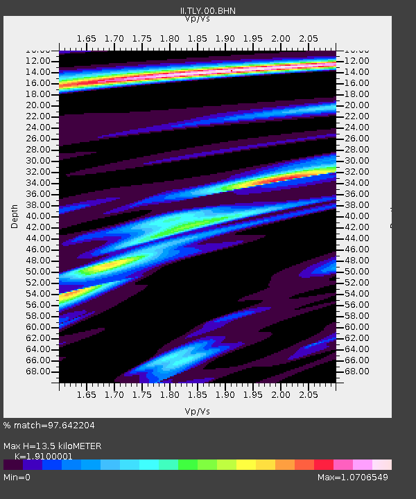
TLY Talaya, Russia - Earthquake Result Viewer

Earthquake location: Volcano Islands, Japan Region
Earthquake latitude/longitude: 22.3/143.7
Earthquake time(UTC): 2000/03/28 (088) 11:00:22 GMT
Earthquake Depth: 126 km
Earthquake Magnitude: 6.8 MB, 7.6 MS, 7.6 MW, 7.6 MW
Earthquake Catalog/Contributor: WHDF/NEIC
Network: II Global Seismograph Network (GSN - IRIS/IDA)
Station: TLY Talaya, Russia
Lat/Lon: 51.68 N/103.64 E
Elevation: 579 m
Distance: 42.5 deg
Az: 323.636 deg
Baz: 118.152 deg
Ray Param: 0.07265815
Estimated Moho Depth: 13.5 km
Estimated Crust Vp/Vs: 1.91
Assumed Crust Vp: 6.419 km/s
Estimated Crust Vs: 3.361 km/s
Estimated Crust Poisson's Ratio: 0.31
Radial Match: 97.642204 %
Radial Bump: 282
Transverse Match: 90.22403 %
Transverse Bump: 400
SOD ConfigId: 3744
Insert Time: 2010-03-01 17:51:52.718 +0000
GWidth: 2.5
Max Bumps: 400
Tol: 0.001

Signal To Noise

ChannelStoNSTALTA
II:TLY:00:BHN:20000328T11:07:35.231985Z5.245569.846588E-71.8771279E-7
II:TLY:00:BHE:20000328T11:07:35.231985Z4.9526121.6898687E-63.4120757E-7
II:TLY:00:BHZ:20000328T11:07:35.231985Z5.58887673.9924025E-67.143479E-7
Arrivals
Ps2.0 SECOND
PpPs5.8 SECOND
PsPs/PpSs7.8 SECOND