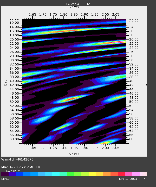
Z55A Blythe, GA, USA - Earthquake Result Viewer
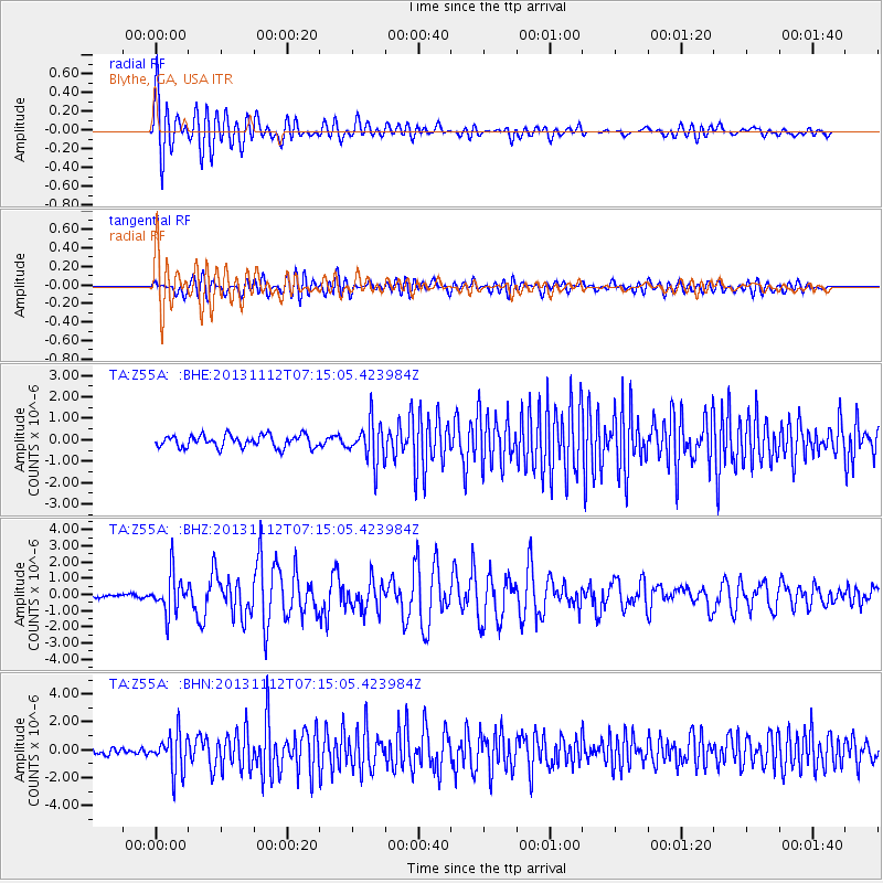
Earthquake location: Near East Coast Of Kamchatka
Earthquake latitude/longitude: 54.7/162.3
Earthquake time(UTC): 2013/11/12 (316) 07:03:51 GMT
Earthquake Depth: 43 km
Earthquake Magnitude: 6.4 MWW, 6.3 MWC, 6.4 MWW, 6.4 MWB, 6.5 MWC, 6.6 MI
Earthquake Catalog/Contributor: NEIC PDE/NEIC COMCAT
Network: TA USArray Transportable Network (new EarthScope stations)
Station: Z55A Blythe, GA, USA
Lat/Lon: 33.22 N/82.14 W
Elevation: 100 m
Distance: 76.5 deg
Az: 51.058 deg
Baz: 327.401 deg
Ray Param: 0.05089963
Estimated Moho Depth: 20.75 km
Estimated Crust Vp/Vs: 2.10
Assumed Crust Vp: 6.565 km/s
Estimated Crust Vs: 3.13 km/s
Estimated Crust Poisson's Ratio: 0.35
Radial Match: 90.42675 %
Radial Bump: 400
Transverse Match: 73.30994 %
Transverse Bump: 400
SOD ConfigId: 626651
Insert Time: 2014-04-19 14:00:32.907 +0000
GWidth: 2.5
Max Bumps: 400
Tol: 0.001

Signal To Noise

ChannelStoNSTALTA
TA:Z55A: :BHZ:20131112T07:15:05.423984Z7.95389751.19775E-61.5058654E-7
TA:Z55A: :BHN:20131112T07:15:05.423984Z6.574781.3851022E-62.1066899E-7
TA:Z55A: :BHE:20131112T07:15:05.423984Z3.30307849.486083E-72.8718915E-7
Arrivals
Ps3.6 SECOND
PpPs9.5 SECOND
PsPs/PpSs13 SECOND