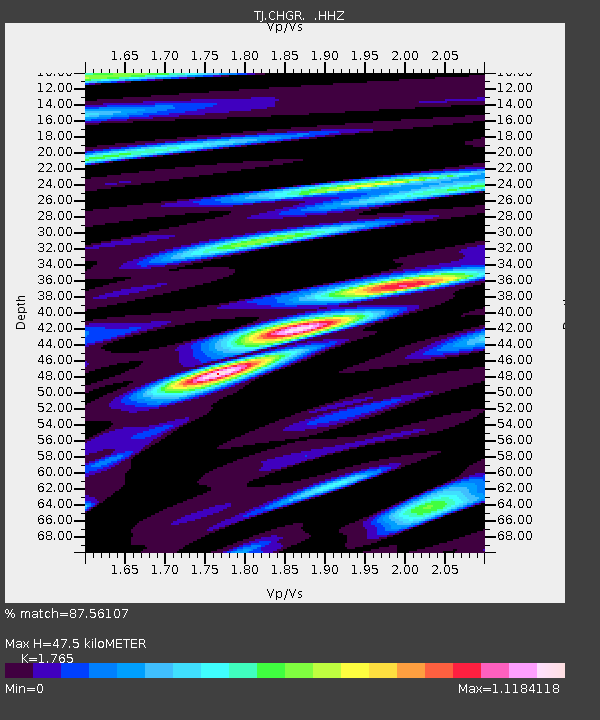
CHGR Chuyangaron, Tajikistan - Earthquake Result Viewer

Earthquake location: Near East Coast Of Kamchatka
Earthquake latitude/longitude: 54.7/162.3
Earthquake time(UTC): 2013/11/12 (316) 07:03:51 GMT
Earthquake Depth: 43 km
Earthquake Magnitude: 6.4 MWW, 6.3 MWC, 6.4 MWW, 6.4 MWB, 6.5 MWC, 6.6 MI
Earthquake Catalog/Contributor: NEIC PDE/NEIC COMCAT
Network: TJ Tajikistan National Seismic Network
Station: CHGR Chuyangaron, Tajikistan
Lat/Lon: 38.66 N/69.16 E
Elevation: 1049 m
Distance: 61.2 deg
Az: 296.875 deg
Baz: 41.416 deg
Ray Param: 0.06093121
Estimated Moho Depth: 47.5 km
Estimated Crust Vp/Vs: 1.76
Assumed Crust Vp: 6.483 km/s
Estimated Crust Vs: 3.673 km/s
Estimated Crust Poisson's Ratio: 0.26
Radial Match: 87.56107 %
Radial Bump: 400
Transverse Match: 77.63149 %
Transverse Bump: 400
SOD ConfigId: 626651
Insert Time: 2014-04-19 14:00:47.458 +0000
GWidth: 2.5
Max Bumps: 400
Tol: 0.001

Signal To Noise

ChannelStoNSTALTA
TJ:CHGR: :HHZ:20131112T07:13:30.840Z26.41166.2949453E-62.3834016E-7
TJ:CHGR: :HHN:20131112T07:13:30.840Z17.7151242.2686183E-61.280611E-7
TJ:CHGR: :HHE:20131112T07:13:30.840Z12.0384861.8223983E-61.5138103E-7
Arrivals
Ps5.9 SECOND
PpPs19 SECOND
PsPs/PpSs25 SECOND