You are here: Home > Network List > US - United States National Seismic Network Stations List
> Station AMTX Amarillo, Texas, USA > Earthquake Result Viewer
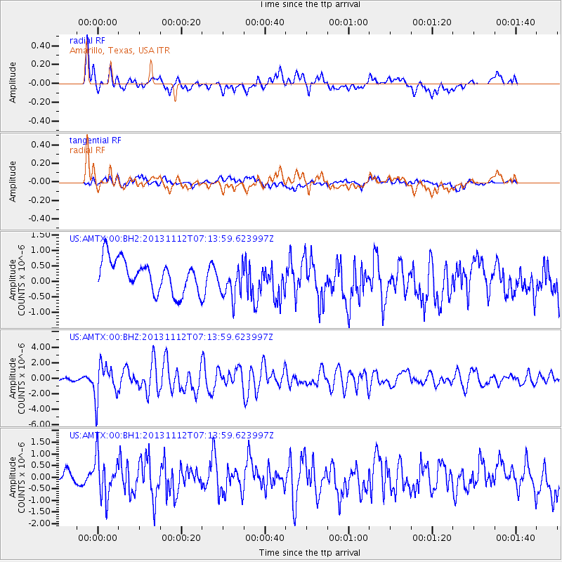
AMTX Amarillo, Texas, USA - Earthquake Result Viewer
*The percent match for this event was below the threshold and hence no stack was calculated.
| Earthquake location: |
Near East Coast Of Kamchatka |
| Earthquake latitude/longitude: |
54.7/162.3 |
| Earthquake time(UTC): |
2013/11/12 (316) 07:03:51 GMT |
| Earthquake Depth: |
43 km |
| Earthquake Magnitude: |
6.4 MWW, 6.3 MWC, 6.4 MWW, 6.4 MWB, 6.5 MWC, 6.6 MI |
| Earthquake Catalog/Contributor: |
NEIC PDE/NEIC COMCAT |
|
| Network: |
US United States National Seismic Network |
| Station: |
AMTX Amarillo, Texas, USA |
| Lat/Lon: |
34.53 N/101.41 W |
| Elevation: |
1010 m |
|
| Distance: |
66.0 deg |
| Az: |
63.943 deg |
| Baz: |
320.816 deg |
| Ray Param: |
$rayparam |
*The percent match for this event was below the threshold and hence was not used in the summary stack. |
|
| Radial Match: |
67.48481 % |
| Radial Bump: |
400 |
| Transverse Match: |
62.153156 % |
| Transverse Bump: |
400 |
| SOD ConfigId: |
626651 |
| Insert Time: |
2014-04-19 14:01:33.486 +0000 |
| GWidth: |
2.5 |
| Max Bumps: |
400 |
| Tol: |
0.001 |
|
Signal To Noise
| Channel | StoN | STA | LTA |
| US:AMTX:00:BHZ:20131112T07:13:59.623997Z | 12.295276 | 2.2611307E-6 | 1.839024E-7 |
| US:AMTX:00:BH1:20131112T07:13:59.623997Z | 3.2044036 | 8.903717E-7 | 2.778588E-7 |
| US:AMTX:00:BH2:20131112T07:13:59.623997Z | 1.2231128 | 5.804927E-7 | 4.7460276E-7 |
| Arrivals |
| Ps | |
| PpPs | |
| PsPs/PpSs | |


