You are here: Home > Network List > US - United States National Seismic Network Stations List
> Station BRAL Brewton, Alabama, USA > Earthquake Result Viewer
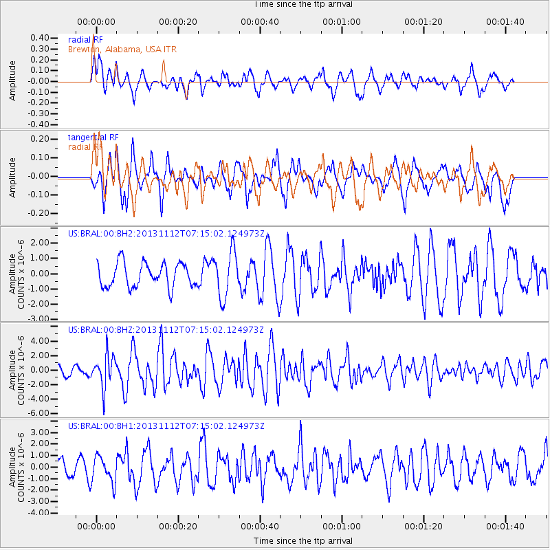
BRAL Brewton, Alabama, USA - Earthquake Result Viewer
*The percent match for this event was below the threshold and hence no stack was calculated.
| Earthquake location: |
Near East Coast Of Kamchatka |
| Earthquake latitude/longitude: |
54.7/162.3 |
| Earthquake time(UTC): |
2013/11/12 (316) 07:03:51 GMT |
| Earthquake Depth: |
43 km |
| Earthquake Magnitude: |
6.4 MWW, 6.3 MWC, 6.4 MWW, 6.4 MWB, 6.5 MWC, 6.6 MI |
| Earthquake Catalog/Contributor: |
NEIC PDE/NEIC COMCAT |
|
| Network: |
US United States National Seismic Network |
| Station: |
BRAL Brewton, Alabama, USA |
| Lat/Lon: |
31.01 N/87.06 W |
| Elevation: |
61 m |
|
| Distance: |
76.0 deg |
| Az: |
55.895 deg |
| Baz: |
325.946 deg |
| Ray Param: |
$rayparam |
*The percent match for this event was below the threshold and hence was not used in the summary stack. |
|
| Radial Match: |
66.2174 % |
| Radial Bump: |
398 |
| Transverse Match: |
60.754204 % |
| Transverse Bump: |
370 |
| SOD ConfigId: |
626651 |
| Insert Time: |
2014-04-19 14:01:42.334 +0000 |
| GWidth: |
2.5 |
| Max Bumps: |
400 |
| Tol: |
0.001 |
|
Signal To Noise
| Channel | StoN | STA | LTA |
| US:BRAL:00:BHZ:20131112T07:15:02.124973Z | 5.4590263 | 2.2807733E-6 | 4.177986E-7 |
| US:BRAL:00:BH1:20131112T07:15:02.124973Z | 2.0411103 | 1.0883682E-6 | 5.3322367E-7 |
| US:BRAL:00:BH2:20131112T07:15:02.124973Z | 2.0197804 | 1.5745866E-6 | 7.7958305E-7 |
| Arrivals |
| Ps | |
| PpPs | |
| PsPs/PpSs | |


