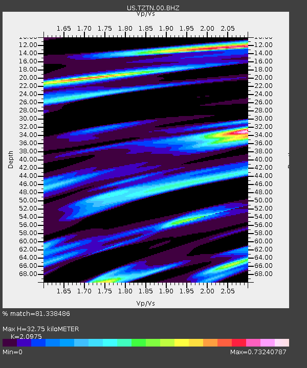
TZTN Tazewell, Tennessee, USA - Earthquake Result Viewer

Earthquake location: Near East Coast Of Kamchatka
Earthquake latitude/longitude: 54.7/162.3
Earthquake time(UTC): 2013/11/12 (316) 07:03:51 GMT
Earthquake Depth: 43 km
Earthquake Magnitude: 6.4 MWW, 6.3 MWC, 6.4 MWW, 6.4 MWB, 6.5 MWC, 6.6 MI
Earthquake Catalog/Contributor: NEIC PDE/NEIC COMCAT
Network: US United States National Seismic Network
Station: TZTN Tazewell, Tennessee, USA
Lat/Lon: 36.54 N/83.55 W
Elevation: 394 m
Distance: 73.1 deg
Az: 50.19 deg
Baz: 326.367 deg
Ray Param: 0.053178217
Estimated Moho Depth: 32.75 km
Estimated Crust Vp/Vs: 2.10
Assumed Crust Vp: 6.476 km/s
Estimated Crust Vs: 3.087 km/s
Estimated Crust Poisson's Ratio: 0.35
Radial Match: 81.338486 %
Radial Bump: 400
Transverse Match: 55.44443 %
Transverse Bump: 400
SOD ConfigId: 626651
Insert Time: 2014-04-19 14:03:17.645 +0000
GWidth: 2.5
Max Bumps: 400
Tol: 0.001

Signal To Noise

ChannelStoNSTALTA
US:TZTN:00:BHZ:20131112T07:14:45.749973Z4.24340771.0417516E-62.4549882E-7
US:TZTN:00:BH1:20131112T07:14:45.749973Z1.82213954.64253E-72.5478454E-7
US:TZTN:00:BH2:20131112T07:14:45.749973Z0.985587242.9335735E-72.9764726E-7
Arrivals
Ps5.7 SECOND
PpPs15 SECOND
PsPs/PpSs21 SECOND