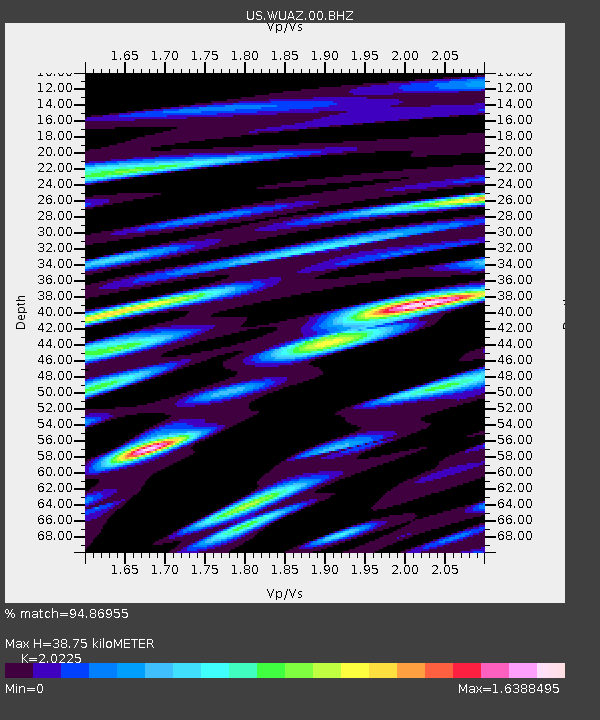
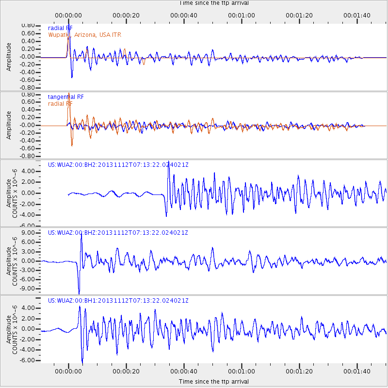
WUAZ Wupatki, Arizona, USA - Earthquake Result Viewer

Earthquake location: Near East Coast Of Kamchatka
Earthquake latitude/longitude: 54.7/162.3
Earthquake time(UTC): 2013/11/12 (316) 07:03:51 GMT
Earthquake Depth: 43 km
Earthquake Magnitude: 6.4 MWW, 6.3 MWC, 6.4 MWW, 6.4 MWB, 6.5 MWC, 6.6 MI
Earthquake Catalog/Contributor: NEIC PDE/NEIC COMCAT
Network: US United States National Seismic Network
Station: WUAZ Wupatki, Arizona, USA
Lat/Lon: 35.52 N/111.37 W
Elevation: 1592 m
Distance: 59.9 deg
Az: 70.191 deg
Baz: 317.96 deg
Ray Param: 0.061785143
Estimated Moho Depth: 38.75 km
Estimated Crust Vp/Vs: 2.02
Assumed Crust Vp: 6.207 km/s
Estimated Crust Vs: 3.069 km/s
Estimated Crust Poisson's Ratio: 0.34
Radial Match: 94.86955 %
Radial Bump: 400
Transverse Match: 84.26252 %
Transverse Bump: 400
SOD ConfigId: 626651
Insert Time: 2014-04-19 14:03:27.263 +0000
GWidth: 2.5
Max Bumps: 400
Tol: 0.001

Signal To Noise

ChannelStoNSTALTA
US:WUAZ:00:BHZ:20131112T07:13:22.024021Z19.3202763.7779646E-61.9554403E-7
US:WUAZ:00:BH1:20131112T07:13:22.024021Z15.5049562.0686136E-61.3341628E-7
US:WUAZ:00:BH2:20131112T07:13:22.024021Z7.3535451.8589373E-62.527947E-7
Arrivals
Ps6.6 SECOND
PpPs18 SECOND
PsPs/PpSs25 SECOND