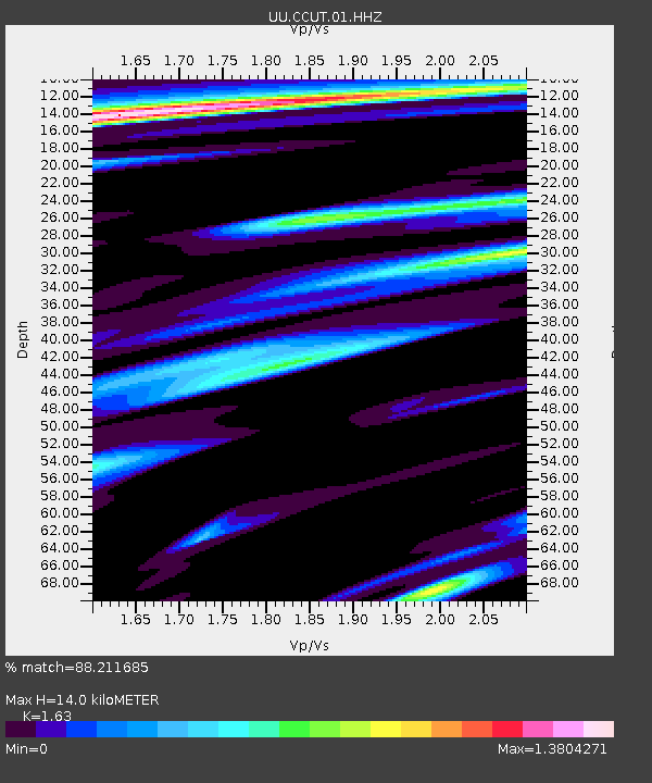
CCUT Cedar City, UT, USA - Earthquake Result Viewer
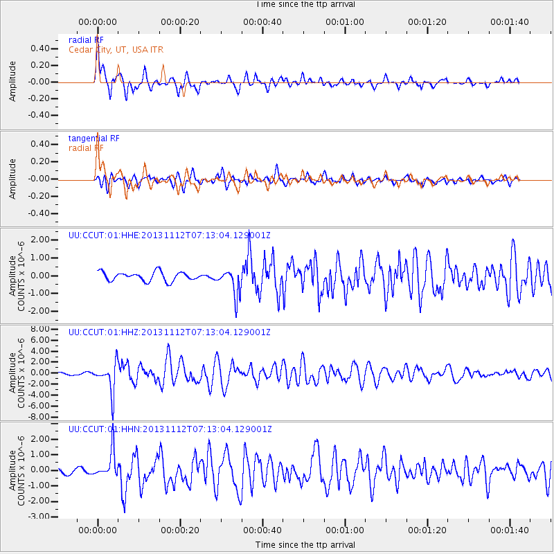
Earthquake location: Near East Coast Of Kamchatka
Earthquake latitude/longitude: 54.7/162.3
Earthquake time(UTC): 2013/11/12 (316) 07:03:51 GMT
Earthquake Depth: 43 km
Earthquake Magnitude: 6.4 MWW, 6.3 MWC, 6.4 MWW, 6.4 MWB, 6.5 MWC, 6.6 MI
Earthquake Catalog/Contributor: NEIC PDE/NEIC COMCAT
Network: UU University of Utah Regional Network
Station: CCUT Cedar City, UT, USA
Lat/Lon: 37.55 N/113.36 W
Elevation: 2127 m
Distance: 57.3 deg
Az: 69.959 deg
Baz: 316.66 deg
Ray Param: 0.06346368
Estimated Moho Depth: 14.0 km
Estimated Crust Vp/Vs: 1.63
Assumed Crust Vp: 6.194 km/s
Estimated Crust Vs: 3.8 km/s
Estimated Crust Poisson's Ratio: 0.20
Radial Match: 88.211685 %
Radial Bump: 400
Transverse Match: 76.257416 %
Transverse Bump: 400
SOD ConfigId: 626651
Insert Time: 2014-04-19 14:03:38.654 +0000
GWidth: 2.5
Max Bumps: 400
Tol: 0.001

Signal To Noise

ChannelStoNSTALTA
UU:CCUT:01:HHZ:20131112T07:13:04.129001Z10.0831912.7507E-62.7280058E-7
UU:CCUT:01:HHN:20131112T07:13:04.129001Z6.2238219.1538817E-71.4707815E-7
UU:CCUT:01:HHE:20131112T07:13:04.129001Z3.01768047.686598E-72.5471877E-7
Arrivals
Ps1.5 SECOND
PpPs5.7 SECOND
PsPs/PpSs7.2 SECOND