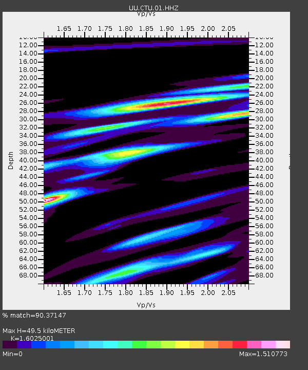
CTU Camp Tracy, UT, USA - Earthquake Result Viewer

Earthquake location: Near East Coast Of Kamchatka
Earthquake latitude/longitude: 54.7/162.3
Earthquake time(UTC): 2013/11/12 (316) 07:03:51 GMT
Earthquake Depth: 43 km
Earthquake Magnitude: 6.4 MWW, 6.3 MWC, 6.4 MWW, 6.4 MWB, 6.5 MWC, 6.6 MI
Earthquake Catalog/Contributor: NEIC PDE/NEIC COMCAT
Network: UU University of Utah Regional Network
Station: CTU Camp Tracy, UT, USA
Lat/Lon: 40.69 N/111.75 W
Elevation: 1731 m
Distance: 55.9 deg
Az: 66.274 deg
Baz: 315.647 deg
Ray Param: 0.06436945
Estimated Moho Depth: 49.5 km
Estimated Crust Vp/Vs: 1.60
Assumed Crust Vp: 6.155 km/s
Estimated Crust Vs: 3.841 km/s
Estimated Crust Poisson's Ratio: 0.18
Radial Match: 90.37147 %
Radial Bump: 400
Transverse Match: 86.97133 %
Transverse Bump: 400
SOD ConfigId: 626651
Insert Time: 2014-04-19 14:03:42.080 +0000
GWidth: 2.5
Max Bumps: 400
Tol: 0.001

Signal To Noise

ChannelStoNSTALTA
UU:CTU:01:HHZ:20131112T07:12:54.259006Z14.1192199.598625E-86.798269E-9
UU:CTU:01:HHN:20131112T07:12:54.259006Z5.81452663.377197E-85.808206E-9
UU:CTU:01:HHE:20131112T07:12:54.259006Z11.5452345.285423E-84.578013E-9
Arrivals
Ps5.1 SECOND
PpPs20 SECOND
PsPs/PpSs25 SECOND