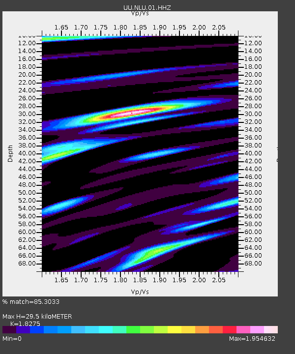
NLU North Lily, UT, USA - Earthquake Result Viewer

Earthquake location: Near East Coast Of Kamchatka
Earthquake latitude/longitude: 54.7/162.3
Earthquake time(UTC): 2013/11/12 (316) 07:03:51 GMT
Earthquake Depth: 43 km
Earthquake Magnitude: 6.4 MWW, 6.3 MWC, 6.4 MWW, 6.4 MWB, 6.5 MWC, 6.6 MI
Earthquake Catalog/Contributor: NEIC PDE/NEIC COMCAT
Network: UU University of Utah Regional Network
Station: NLU North Lily, UT, USA
Lat/Lon: 39.95 N/112.07 W
Elevation: 2036 m
Distance: 56.3 deg
Az: 67.107 deg
Baz: 315.902 deg
Ray Param: 0.06413874
Estimated Moho Depth: 29.5 km
Estimated Crust Vp/Vs: 1.83
Assumed Crust Vp: 6.276 km/s
Estimated Crust Vs: 3.434 km/s
Estimated Crust Poisson's Ratio: 0.29
Radial Match: 85.3033 %
Radial Bump: 400
Transverse Match: 91.26114 %
Transverse Bump: 400
SOD ConfigId: 626651
Insert Time: 2014-04-19 14:04:02.296 +0000
GWidth: 2.5
Max Bumps: 400
Tol: 0.001

Signal To Noise

ChannelStoNSTALTA
UU:NLU:01:HHZ:20131112T07:12:56.78397Z18.3127021.18169986E-76.4528978E-9
UU:NLU:01:HHN:20131112T07:12:56.78397Z13.3744076.1704064E-84.6135926E-9
UU:NLU:01:HHE:20131112T07:12:56.78397Z4.4127442.9914027E-86.779008E-9
Arrivals
Ps4.1 SECOND
PpPs13 SECOND
PsPs/PpSs17 SECOND