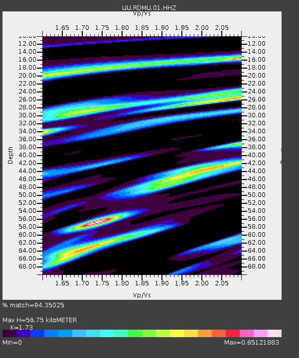
RDMU Red Mountain, UT, USA - Earthquake Result Viewer

Earthquake location: Near East Coast Of Kamchatka
Earthquake latitude/longitude: 54.7/162.3
Earthquake time(UTC): 2013/11/12 (316) 07:03:51 GMT
Earthquake Depth: 43 km
Earthquake Magnitude: 6.4 MWW, 6.3 MWC, 6.4 MWW, 6.4 MWB, 6.5 MWC, 6.6 MI
Earthquake Catalog/Contributor: NEIC PDE/NEIC COMCAT
Network: UU University of Utah Regional Network
Station: RDMU Red Mountain, UT, USA
Lat/Lon: 40.57 N/109.57 W
Elevation: 2087 m
Distance: 57.2 deg
Az: 64.945 deg
Baz: 316.329 deg
Ray Param: 0.06356132
Estimated Moho Depth: 56.75 km
Estimated Crust Vp/Vs: 1.73
Assumed Crust Vp: 6.207 km/s
Estimated Crust Vs: 3.588 km/s
Estimated Crust Poisson's Ratio: 0.25
Radial Match: 94.35025 %
Radial Bump: 265
Transverse Match: 85.242455 %
Transverse Bump: 388
SOD ConfigId: 626651
Insert Time: 2014-04-19 14:04:12.373 +0000
GWidth: 2.5
Max Bumps: 400
Tol: 0.001

Signal To Noise

ChannelStoNSTALTA
UU:RDMU:01:HHZ:20131112T07:13:03.050022Z36.544132.1002714E-75.74722E-9
UU:RDMU:01:HHN:20131112T07:13:03.050022Z10.4569047.068419E-86.7595707E-9
UU:RDMU:01:HHE:20131112T07:13:03.050022Z9.234696.1288574E-86.6367773E-9
Arrivals
Ps7.0 SECOND
PpPs24 SECOND
PsPs/PpSs31 SECOND