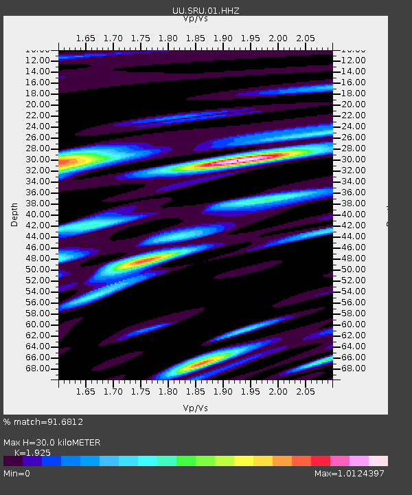
SRU San Rafael Swell, UT, USA - Earthquake Result Viewer

Earthquake location: Near East Coast Of Kamchatka
Earthquake latitude/longitude: 54.7/162.3
Earthquake time(UTC): 2013/11/12 (316) 07:03:51 GMT
Earthquake Depth: 43 km
Earthquake Magnitude: 6.4 MWW, 6.3 MWC, 6.4 MWW, 6.4 MWB, 6.5 MWC, 6.6 MI
Earthquake Catalog/Contributor: NEIC PDE/NEIC COMCAT
Network: UU University of Utah Regional Network
Station: SRU San Rafael Swell, UT, USA
Lat/Lon: 39.11 N/110.52 W
Elevation: 1804 m
Distance: 57.7 deg
Az: 66.767 deg
Baz: 316.7 deg
Ray Param: 0.06320915
Estimated Moho Depth: 30.0 km
Estimated Crust Vp/Vs: 1.92
Assumed Crust Vp: 6.207 km/s
Estimated Crust Vs: 3.224 km/s
Estimated Crust Poisson's Ratio: 0.32
Radial Match: 91.6812 %
Radial Bump: 400
Transverse Match: 87.012985 %
Transverse Bump: 400
SOD ConfigId: 626651
Insert Time: 2014-04-19 14:04:18.435 +0000
GWidth: 2.5
Max Bumps: 400
Tol: 0.001

Signal To Noise

ChannelStoNSTALTA
UU:SRU:01:HHZ:20131112T07:13:06.918979Z17.2275074.1254184E-62.3946694E-7
UU:SRU:01:HHN:20131112T07:13:06.918979Z10.3031621.3044752E-61.2660921E-7
UU:SRU:01:HHE:20131112T07:13:06.918979Z6.72658541.2573607E-61.8692407E-7
Arrivals
Ps4.7 SECOND
PpPs14 SECOND
PsPs/PpSs18 SECOND