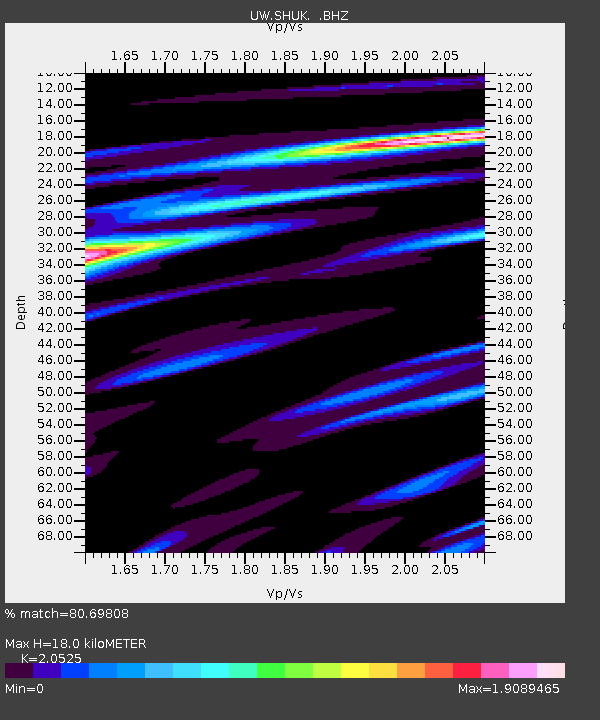
SHUK Shuksan (Mt. Baker Ski Area), WA - Earthquake Result Viewer

Earthquake location: Near East Coast Of Kamchatka
Earthquake latitude/longitude: 54.7/162.3
Earthquake time(UTC): 2013/11/12 (316) 07:03:51 GMT
Earthquake Depth: 43 km
Earthquake Magnitude: 6.4 MWW, 6.3 MWC, 6.4 MWW, 6.4 MWB, 6.5 MWC, 6.6 MI
Earthquake Catalog/Contributor: NEIC PDE/NEIC COMCAT
Network: UW Pacific Northwest Regional Seismic Network
Station: SHUK Shuksan (Mt. Baker Ski Area), WA
Lat/Lon: 48.85 N/121.68 W
Elevation: 1516 m
Distance: 45.3 deg
Az: 64.475 deg
Baz: 307.505 deg
Ray Param: 0.071290284
Estimated Moho Depth: 18.0 km
Estimated Crust Vp/Vs: 2.05
Assumed Crust Vp: 6.566 km/s
Estimated Crust Vs: 3.199 km/s
Estimated Crust Poisson's Ratio: 0.34
Radial Match: 80.69808 %
Radial Bump: 400
Transverse Match: 69.14041 %
Transverse Bump: 400
SOD ConfigId: 626651
Insert Time: 2014-04-19 14:05:39.080 +0000
GWidth: 2.5
Max Bumps: 400
Tol: 0.001

Signal To Noise

ChannelStoNSTALTA
UW:SHUK: :BHZ:20131112T07:11:33.820011Z6.7651134.9957507E-67.3845786E-7
UW:SHUK: :BHN:20131112T07:11:33.820011Z5.34733343.4990992E-66.543634E-7
UW:SHUK: :BHE:20131112T07:11:33.820011Z3.23475893.0125216E-69.312971E-7
Arrivals
Ps3.1 SECOND
PpPs7.9 SECOND
PsPs/PpSs11 SECOND