You are here: Home > Network List > TA - USArray Transportable Network (new EarthScope stations) Stations List
> Station V50A Pikevile, TN, USA > Earthquake Result Viewer
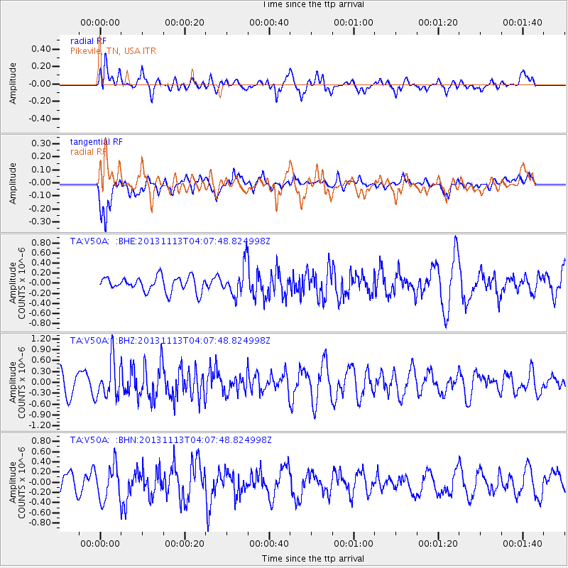
V50A Pikevile, TN, USA - Earthquake Result Viewer
*The percent match for this event was below the threshold and hence no stack was calculated.
| Earthquake location: |
Andreanof Islands, Aleutian Is. |
| Earthquake latitude/longitude: |
51.5/-179.0 |
| Earthquake time(UTC): |
2013/11/13 (317) 03:57:39 GMT |
| Earthquake Depth: |
20 km |
| Earthquake Magnitude: |
5.8 MWW, 5.6 MWB, 5.7 MI, 5.8 MWW, 5.9 MWC, 6.0 ML |
| Earthquake Catalog/Contributor: |
NEIC PDE/NEIC COMCAT |
|
| Network: |
TA USArray Transportable Network (new EarthScope stations) |
| Station: |
V50A Pikevile, TN, USA |
| Lat/Lon: |
35.67 N/85.10 W |
| Elevation: |
287 m |
|
| Distance: |
65.2 deg |
| Az: |
63.459 deg |
| Baz: |
316.68 deg |
| Ray Param: |
$rayparam |
*The percent match for this event was below the threshold and hence was not used in the summary stack. |
|
| Radial Match: |
53.5718 % |
| Radial Bump: |
400 |
| Transverse Match: |
57.680614 % |
| Transverse Bump: |
400 |
| SOD ConfigId: |
626651 |
| Insert Time: |
2014-04-19 14:37:32.257 +0000 |
| GWidth: |
2.5 |
| Max Bumps: |
400 |
| Tol: |
0.001 |
|
Signal To Noise
| Channel | StoN | STA | LTA |
| TA:V50A: :BHZ:20131113T04:07:48.824998Z | 2.1534672 | 5.212275E-7 | 2.4204107E-7 |
| TA:V50A: :BHN:20131113T04:07:48.824998Z | 1.8307741 | 3.411504E-7 | 1.8634218E-7 |
| TA:V50A: :BHE:20131113T04:07:48.824998Z | 2.095774 | 3.0774044E-7 | 1.4683856E-7 |
| Arrivals |
| Ps | |
| PpPs | |
| PsPs/PpSs | |


