You are here: Home > Network List > US - United States National Seismic Network Stations List
> Station EGMT Eagleton, Montana, USA > Earthquake Result Viewer
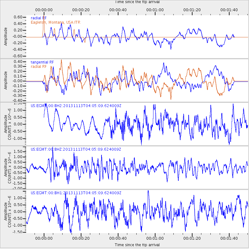
EGMT Eagleton, Montana, USA - Earthquake Result Viewer
*The percent match for this event was below the threshold and hence no stack was calculated.
| Earthquake location: |
Andreanof Islands, Aleutian Is. |
| Earthquake latitude/longitude: |
51.5/-179.0 |
| Earthquake time(UTC): |
2013/11/13 (317) 03:57:39 GMT |
| Earthquake Depth: |
20 km |
| Earthquake Magnitude: |
5.8 MWW, 5.6 MWB, 5.7 MI, 5.8 MWW, 5.9 MWC, 6.0 ML |
| Earthquake Catalog/Contributor: |
NEIC PDE/NEIC COMCAT |
|
| Network: |
US United States National Seismic Network |
| Station: |
EGMT Eagleton, Montana, USA |
| Lat/Lon: |
48.02 N/109.75 W |
| Elevation: |
1055 m |
|
| Distance: |
43.3 deg |
| Az: |
66.19 deg |
| Baz: |
301.679 deg |
| Ray Param: |
$rayparam |
*The percent match for this event was below the threshold and hence was not used in the summary stack. |
|
| Radial Match: |
40.492516 % |
| Radial Bump: |
400 |
| Transverse Match: |
47.927254 % |
| Transverse Bump: |
400 |
| SOD ConfigId: |
626651 |
| Insert Time: |
2014-04-19 14:40:19.424 +0000 |
| GWidth: |
2.5 |
| Max Bumps: |
400 |
| Tol: |
0.001 |
|
Signal To Noise
| Channel | StoN | STA | LTA |
| US:EGMT:00:BHZ:20131113T04:05:09.624009Z | 4.3474035 | 6.565009E-7 | 1.5100989E-7 |
| US:EGMT:00:BH1:20131113T04:05:09.624009Z | 0.9252462 | 3.4132734E-7 | 3.6890432E-7 |
| US:EGMT:00:BH2:20131113T04:05:09.624009Z | 1.2756217 | 6.7615196E-7 | 5.300568E-7 |
| Arrivals |
| Ps | |
| PpPs | |
| PsPs/PpSs | |


