You are here: Home > Network List > UW - Pacific Northwest Regional Seismic Network Stations List
> Station LEBA Lebam, WA, USA > Earthquake Result Viewer
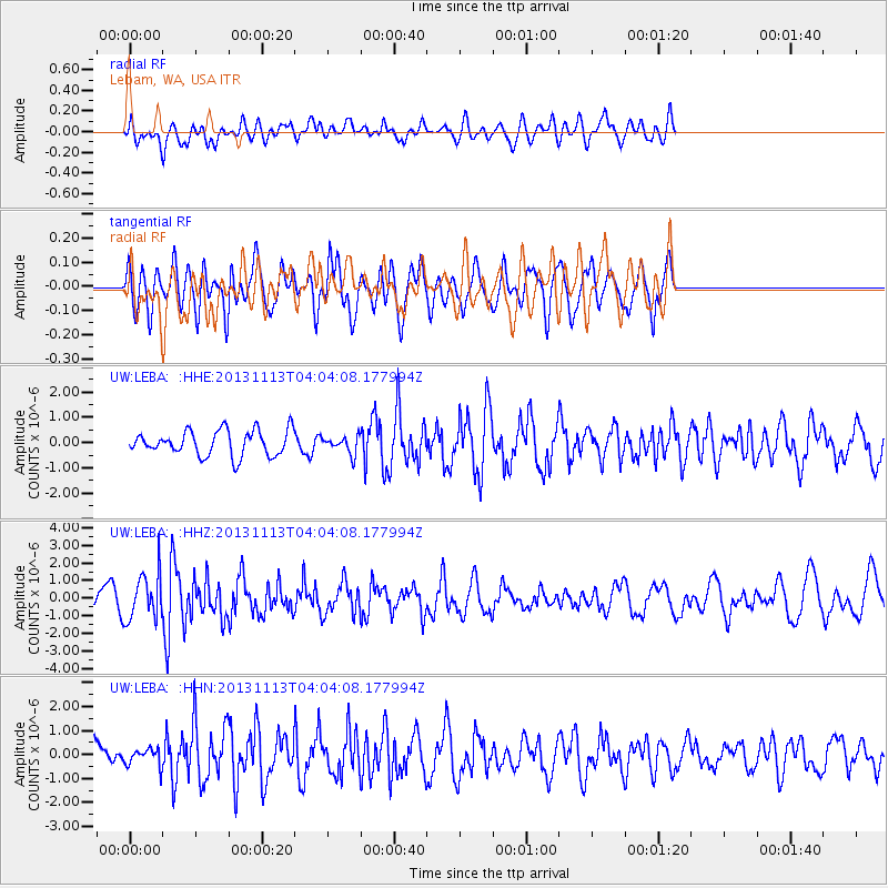
LEBA Lebam, WA, USA - Earthquake Result Viewer
*The percent match for this event was below the threshold and hence no stack was calculated.
| Earthquake location: |
Andreanof Islands, Aleutian Is. |
| Earthquake latitude/longitude: |
51.5/-179.0 |
| Earthquake time(UTC): |
2013/11/13 (317) 03:57:39 GMT |
| Earthquake Depth: |
20 km |
| Earthquake Magnitude: |
5.8 MWW, 5.6 MWB, 5.7 MI, 5.8 MWW, 5.9 MWC, 6.0 ML |
| Earthquake Catalog/Contributor: |
NEIC PDE/NEIC COMCAT |
|
| Network: |
UW Pacific Northwest Regional Seismic Network |
| Station: |
LEBA Lebam, WA, USA |
| Lat/Lon: |
46.55 N/123.56 W |
| Elevation: |
73 m |
|
| Distance: |
35.9 deg |
| Az: |
75.595 deg |
| Baz: |
298.807 deg |
| Ray Param: |
$rayparam |
*The percent match for this event was below the threshold and hence was not used in the summary stack. |
|
| Radial Match: |
59.05962 % |
| Radial Bump: |
400 |
| Transverse Match: |
56.329124 % |
| Transverse Bump: |
400 |
| SOD ConfigId: |
626651 |
| Insert Time: |
2014-04-19 14:43:10.284 +0000 |
| GWidth: |
2.5 |
| Max Bumps: |
400 |
| Tol: |
0.001 |
|
Signal To Noise
| Channel | StoN | STA | LTA |
| UW:LEBA: :HHZ:20131113T04:04:08.177994Z | 2.5120153 | 1.3196683E-6 | 5.253425E-7 |
| UW:LEBA: :HHN:20131113T04:04:08.177994Z | 0.62215805 | 3.4814246E-7 | 5.5957236E-7 |
| UW:LEBA: :HHE:20131113T04:04:08.177994Z | 0.6965959 | 3.43205E-7 | 4.9268874E-7 |
| Arrivals |
| Ps | |
| PpPs | |
| PsPs/PpSs | |


