You are here: Home > Network List > GT - Global Telemetered Seismograph Network (USAF/USGS) Stations List
> Station LPAZ La Paz , Bolivia > Earthquake Result Viewer
LPAZ La Paz , Bolivia - Earthquake Result Viewer
| Earthquake location: |
Scotia Sea |
| Earthquake latitude/longitude: |
-60.3/-47.1 |
| Earthquake time(UTC): |
2013/11/13 (317) 23:45:47 GMT |
| Earthquake Depth: |
11 km |
| Earthquake Magnitude: |
6.1 MWW, 6.0 MWB, 6.1 MWW, 6.1 MWC |
| Earthquake Catalog/Contributor: |
NEIC PDE/NEIC COMCAT |
|
| Network: |
GT Global Telemetered Seismograph Network (USAF/USGS) |
| Station: |
LPAZ La Paz , Bolivia |
| Lat/Lon: |
16.17 S/68.08 W |
| Elevation: |
4817 m |
|
| Distance: |
46.6 deg |
| Az: |
331.77 deg |
| Baz: |
165.803 deg |
| Ray Param: |
0.07054283 |
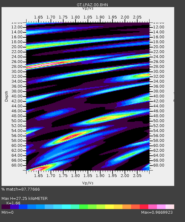
| Estimated Moho Depth: |
27.25 km |
| Estimated Crust Vp/Vs: |
1.66 |
| Assumed Crust Vp: |
6.454 km/s |
| Estimated Crust Vs: |
3.888 km/s |
| Estimated Crust Poisson's Ratio: |
0.22 |
|
| Radial Match: |
87.77666 % |
| Radial Bump: |
400 |
| Transverse Match: |
69.561584 % |
| Transverse Bump: |
400 |
| SOD ConfigId: |
626651 |
| Insert Time: |
2014-04-19 14:49:12.243 +0000 |
| GWidth: |
2.5 |
| Max Bumps: |
400 |
| Tol: |
0.001 |
|
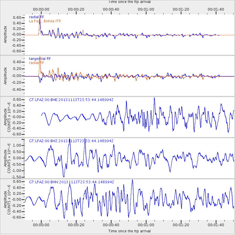
Signal To Noise
| Channel | StoN | STA | LTA |
| GT:LPAZ:00:BHZ:20131113T23:53:44.148994Z | 3.2340484 | 4.1739528E-7 | 1.2906278E-7 |
| GT:LPAZ:00:BHN:20131113T23:53:44.148994Z | 1.6037518 | 1.2269923E-7 | 7.650762E-8 |
| GT:LPAZ:00:BHE:20131113T23:53:44.148994Z | 0.9505635 | 9.482957E-8 | 9.976143E-8 |
| Arrivals |
| Ps | 3.0 SECOND |
| PpPs | 10 SECOND |
| PsPs/PpSs | 13 SECOND |


