You are here: Home > Network List > TA - USArray Transportable Network (new EarthScope stations) Stations List
> Station A36M Sachs Harbour, NT, CAN > Earthquake Result Viewer
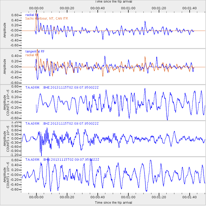
A36M Sachs Harbour, NT, CAN - Earthquake Result Viewer
*The percent match for this event was below the threshold and hence no stack was calculated.
| Earthquake location: |
Hokkaido, Japan Region |
| Earthquake latitude/longitude: |
41.4/142.2 |
| Earthquake time(UTC): |
2013/11/15 (319) 02:00:33 GMT |
| Earthquake Depth: |
46 km |
| Earthquake Magnitude: |
5.5 MWB, 5.6 MWC |
| Earthquake Catalog/Contributor: |
NEIC PDE/NEIC COMCAT |
|
| Network: |
TA USArray Transportable Network (new EarthScope stations) |
| Station: |
A36M Sachs Harbour, NT, CAN |
| Lat/Lon: |
71.99 N/125.25 W |
| Elevation: |
32 m |
|
| Distance: |
52.0 deg |
| Az: |
23.237 deg |
| Baz: |
287.525 deg |
| Ray Param: |
$rayparam |
*The percent match for this event was below the threshold and hence was not used in the summary stack. |
|
| Radial Match: |
64.17635 % |
| Radial Bump: |
400 |
| Transverse Match: |
50.524094 % |
| Transverse Bump: |
400 |
| SOD ConfigId: |
626651 |
| Insert Time: |
2014-04-19 15:13:27.749 +0000 |
| GWidth: |
2.5 |
| Max Bumps: |
400 |
| Tol: |
0.001 |
|
Signal To Noise
| Channel | StoN | STA | LTA |
| TA:A36M: :BHZ:20131115T02:09:07.950022Z | 2.3083642 | 4.081998E-7 | 1.768351E-7 |
| TA:A36M: :BHN:20131115T02:09:07.950022Z | 1.9102025 | 2.5708422E-7 | 1.3458481E-7 |
| TA:A36M: :BHE:20131115T02:09:07.950022Z | 1.0269029 | 1.7603685E-7 | 1.7142503E-7 |
| Arrivals |
| Ps | |
| PpPs | |
| PsPs/PpSs | |


