You are here: Home > Network List > TA - USArray Transportable Network (new EarthScope stations) Stations List
> Station J62A Henniker, NH, USA > Earthquake Result Viewer
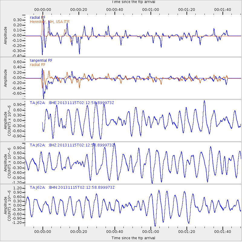
J62A Henniker, NH, USA - Earthquake Result Viewer
*The percent match for this event was below the threshold and hence no stack was calculated.
| Earthquake location: |
Hokkaido, Japan Region |
| Earthquake latitude/longitude: |
41.4/142.2 |
| Earthquake time(UTC): |
2013/11/15 (319) 02:00:33 GMT |
| Earthquake Depth: |
46 km |
| Earthquake Magnitude: |
5.5 MWB, 5.6 MWC |
| Earthquake Catalog/Contributor: |
NEIC PDE/NEIC COMCAT |
|
| Network: |
TA USArray Transportable Network (new EarthScope stations) |
| Station: |
J62A Henniker, NH, USA |
| Lat/Lon: |
43.23 N/71.81 W |
| Elevation: |
266 m |
|
| Distance: |
90.3 deg |
| Az: |
24.119 deg |
| Baz: |
335.141 deg |
| Ray Param: |
$rayparam |
*The percent match for this event was below the threshold and hence was not used in the summary stack. |
|
| Radial Match: |
72.53342 % |
| Radial Bump: |
354 |
| Transverse Match: |
64.99339 % |
| Transverse Bump: |
400 |
| SOD ConfigId: |
626651 |
| Insert Time: |
2014-04-19 15:16:18.384 +0000 |
| GWidth: |
2.5 |
| Max Bumps: |
400 |
| Tol: |
0.001 |
|
Signal To Noise
| Channel | StoN | STA | LTA |
| TA:J62A: :BHZ:20131115T02:12:58.899973Z | 0.80747265 | 4.215903E-7 | 5.2211095E-7 |
| TA:J62A: :BHN:20131115T02:12:58.899973Z | 0.64257187 | 2.8906297E-7 | 4.498531E-7 |
| TA:J62A: :BHE:20131115T02:12:58.899973Z | 1.5206157 | 7.5354455E-7 | 4.955523E-7 |
| Arrivals |
| Ps | |
| PpPs | |
| PsPs/PpSs | |


