You are here: Home > Network List > TA - USArray Transportable Network (new EarthScope stations) Stations List
> Station V55A Taylorsville, NC, USA > Earthquake Result Viewer
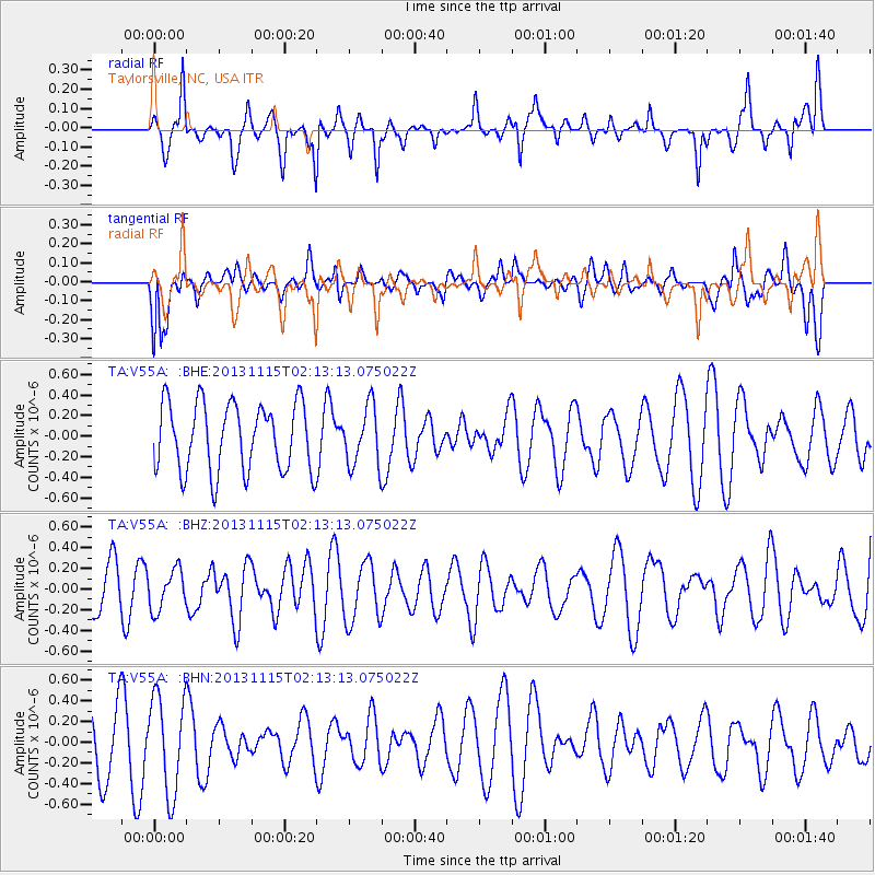
V55A Taylorsville, NC, USA - Earthquake Result Viewer
*The percent match for this event was below the threshold and hence no stack was calculated.
| Earthquake location: |
Hokkaido, Japan Region |
| Earthquake latitude/longitude: |
41.4/142.2 |
| Earthquake time(UTC): |
2013/11/15 (319) 02:00:33 GMT |
| Earthquake Depth: |
46 km |
| Earthquake Magnitude: |
5.5 MWB, 5.6 MWC |
| Earthquake Catalog/Contributor: |
NEIC PDE/NEIC COMCAT |
|
| Network: |
TA USArray Transportable Network (new EarthScope stations) |
| Station: |
V55A Taylorsville, NC, USA |
| Lat/Lon: |
35.85 N/81.21 W |
| Elevation: |
306 m |
|
| Distance: |
93.4 deg |
| Az: |
33.993 deg |
| Baz: |
328.835 deg |
| Ray Param: |
$rayparam |
*The percent match for this event was below the threshold and hence was not used in the summary stack. |
|
| Radial Match: |
56.280815 % |
| Radial Bump: |
347 |
| Transverse Match: |
44.38414 % |
| Transverse Bump: |
400 |
| SOD ConfigId: |
626651 |
| Insert Time: |
2014-04-19 15:20:25.623 +0000 |
| GWidth: |
2.5 |
| Max Bumps: |
400 |
| Tol: |
0.001 |
|
Signal To Noise
| Channel | StoN | STA | LTA |
| TA:V55A: :BHZ:20131115T02:13:13.075022Z | 0.7236818 | 1.9340824E-7 | 2.672559E-7 |
| TA:V55A: :BHN:20131115T02:13:13.075022Z | 2.0195322 | 4.680064E-7 | 2.3174E-7 |
| TA:V55A: :BHE:20131115T02:13:13.075022Z | 0.871587 | 2.8894524E-7 | 3.3151628E-7 |
| Arrivals |
| Ps | |
| PpPs | |
| PsPs/PpSs | |


