You are here: Home > Network List > TA - USArray Transportable Network (new EarthScope stations) Stations List
> Station X59A McDuffie Farm, Elizabethtown, NC, USA > Earthquake Result Viewer
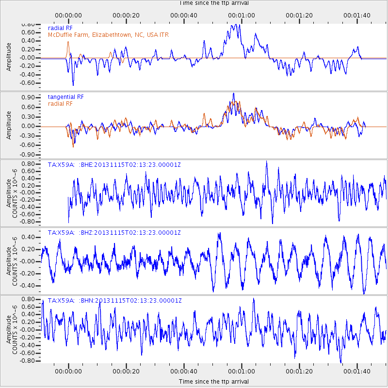
X59A McDuffie Farm, Elizabethtown, NC, USA - Earthquake Result Viewer
*The percent match for this event was below the threshold and hence no stack was calculated.
| Earthquake location: |
Hokkaido, Japan Region |
| Earthquake latitude/longitude: |
41.4/142.2 |
| Earthquake time(UTC): |
2013/11/15 (319) 02:00:33 GMT |
| Earthquake Depth: |
46 km |
| Earthquake Magnitude: |
5.5 MWB, 5.6 MWC |
| Earthquake Catalog/Contributor: |
NEIC PDE/NEIC COMCAT |
|
| Network: |
TA USArray Transportable Network (new EarthScope stations) |
| Station: |
X59A McDuffie Farm, Elizabethtown, NC, USA |
| Lat/Lon: |
34.57 N/78.60 W |
| Elevation: |
29 m |
|
| Distance: |
95.6 deg |
| Az: |
32.789 deg |
| Baz: |
330.43 deg |
| Ray Param: |
$rayparam |
*The percent match for this event was below the threshold and hence was not used in the summary stack. |
|
| Radial Match: |
37.070896 % |
| Radial Bump: |
400 |
| Transverse Match: |
41.817173 % |
| Transverse Bump: |
400 |
| SOD ConfigId: |
626651 |
| Insert Time: |
2014-04-19 15:21:02.903 +0000 |
| GWidth: |
2.5 |
| Max Bumps: |
400 |
| Tol: |
0.001 |
|
Signal To Noise
| Channel | StoN | STA | LTA |
| TA:X59A: :BHZ:20131115T02:13:23.00001Z | 0.7989384 | 1.2132124E-7 | 1.5185306E-7 |
| TA:X59A: :BHN:20131115T02:13:23.00001Z | 0.8229312 | 4.715916E-7 | 5.7306323E-7 |
| TA:X59A: :BHE:20131115T02:13:23.00001Z | 0.9309982 | 2.2789837E-7 | 2.4478928E-7 |
| Arrivals |
| Ps | |
| PpPs | |
| PsPs/PpSs | |


