You are here: Home > Network List > UW - Pacific Northwest Regional Seismic Network Stations List
> Station UMAT Pilot Rock, OR, USA > Earthquake Result Viewer
UMAT Pilot Rock, OR, USA - Earthquake Result Viewer
*The percent match for this event was below the threshold and hence no stack was calculated.
| Earthquake location: |
Hokkaido, Japan Region |
| Earthquake latitude/longitude: |
41.4/142.2 |
| Earthquake time(UTC): |
2013/11/15 (319) 02:00:33 GMT |
| Earthquake Depth: |
46 km |
| Earthquake Magnitude: |
5.5 MWB, 5.6 MWC |
| Earthquake Catalog/Contributor: |
NEIC PDE/NEIC COMCAT |
|
| Network: |
UW Pacific Northwest Regional Seismic Network |
| Station: |
UMAT Pilot Rock, OR, USA |
| Lat/Lon: |
45.29 N/118.96 W |
| Elevation: |
1318 m |
|
| Distance: |
67.3 deg |
| Az: |
49.093 deg |
| Baz: |
306.382 deg |
| Ray Param: |
$rayparam |
*The percent match for this event was below the threshold and hence was not used in the summary stack. |
|
| Radial Match: |
39.200325 % |
| Radial Bump: |
400 |
| Transverse Match: |
34.32905 % |
| Transverse Bump: |
400 |
| SOD ConfigId: |
626651 |
| Insert Time: |
2014-04-19 15:23:41.669 +0000 |
| GWidth: |
2.5 |
| Max Bumps: |
400 |
| Tol: |
0.001 |
|
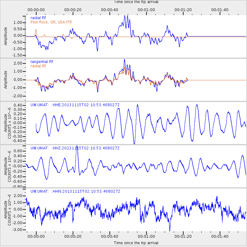
Signal To Noise
| Channel | StoN | STA | LTA |
| UW:UMAT: :HHZ:20131115T02:10:53.468027Z | 1.5918542 | 2.0458344E-7 | 1.2851896E-7 |
| UW:UMAT: :HHN:20131115T02:10:53.468027Z | 1.5005716 | 1.2320081E-6 | 8.210259E-7 |
| UW:UMAT: :HHE:20131115T02:10:53.468027Z | 0.8722118 | 1.06197255E-7 | 1.2175626E-7 |
| Arrivals |
| Ps | |
| PpPs | |
| PsPs/PpSs | |


