You are here: Home > Network List > GH - Ghana Digital Seismic Network Stations List
> Station KLEF Ho, Ghana > Earthquake Result Viewer
KLEF Ho, Ghana - Earthquake Result Viewer
| Earthquake location: |
Scotia Sea |
| Earthquake latitude/longitude: |
-60.3/-47.1 |
| Earthquake time(UTC): |
2013/11/16 (320) 03:34:31 GMT |
| Earthquake Depth: |
10 km |
| Earthquake Magnitude: |
6.9 MWW, 6.8 MWB, 6.9 MWC, 7.4 MI |
| Earthquake Catalog/Contributor: |
NEIC PDE/NEIC COMCAT |
|
| Network: |
GH Ghana Digital Seismic Network |
| Station: |
KLEF Ho, Ghana |
| Lat/Lon: |
6.61 N/0.44 E |
| Elevation: |
313 m |
|
| Distance: |
76.4 deg |
| Az: |
48.907 deg |
| Baz: |
202.223 deg |
| Ray Param: |
0.05102954 |
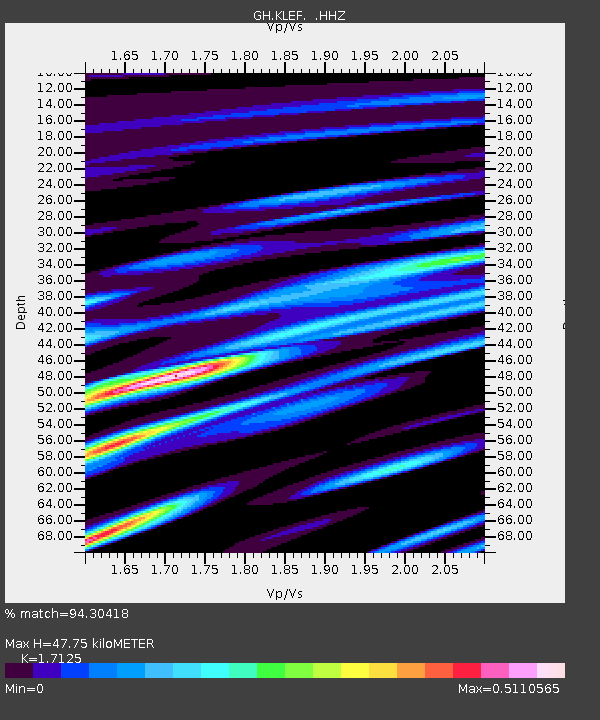
| Estimated Moho Depth: |
47.75 km |
| Estimated Crust Vp/Vs: |
1.71 |
| Assumed Crust Vp: |
6.612 km/s |
| Estimated Crust Vs: |
3.861 km/s |
| Estimated Crust Poisson's Ratio: |
0.24 |
|
| Radial Match: |
94.30418 % |
| Radial Bump: |
368 |
| Transverse Match: |
84.190575 % |
| Transverse Bump: |
400 |
| SOD ConfigId: |
626651 |
| Insert Time: |
2014-04-19 15:27:13.889 +0000 |
| GWidth: |
2.5 |
| Max Bumps: |
400 |
| Tol: |
0.001 |
|

Signal To Noise
| Channel | StoN | STA | LTA |
| GH:KLEF: :HHZ:20131116T03:45:49.289998Z | 8.499794 | 7.640113E-7 | 8.988586E-8 |
| GH:KLEF: :HHN:20131116T03:45:49.289998Z | 3.2926567 | 2.7365752E-7 | 8.3111466E-8 |
| GH:KLEF: :HHE:20131116T03:45:49.289998Z | 1.6574973 | 1.2633633E-7 | 7.622114E-8 |
| Arrivals |
| Ps | 5.3 SECOND |
| PpPs | 19 SECOND |
| PsPs/PpSs | 24 SECOND |


