You are here: Home > Network List > GH - Ghana Digital Seismic Network Stations List
> Station KUKU Kukurantumi, Ghana > Earthquake Result Viewer
KUKU Kukurantumi, Ghana - Earthquake Result Viewer
| Earthquake location: |
Scotia Sea |
| Earthquake latitude/longitude: |
-60.3/-47.1 |
| Earthquake time(UTC): |
2013/11/16 (320) 03:34:31 GMT |
| Earthquake Depth: |
10 km |
| Earthquake Magnitude: |
6.9 MWW, 6.8 MWB, 6.9 MWC, 7.4 MI |
| Earthquake Catalog/Contributor: |
NEIC PDE/NEIC COMCAT |
|
| Network: |
GH Ghana Digital Seismic Network |
| Station: |
KUKU Kukurantumi, Ghana |
| Lat/Lon: |
6.19 N/0.37 W |
| Elevation: |
240 m |
|
| Distance: |
75.7 deg |
| Az: |
48.302 deg |
| Baz: |
201.987 deg |
| Ray Param: |
0.051495768 |
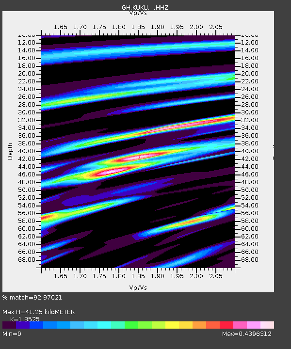
| Estimated Moho Depth: |
41.25 km |
| Estimated Crust Vp/Vs: |
1.85 |
| Assumed Crust Vp: |
6.419 km/s |
| Estimated Crust Vs: |
3.465 km/s |
| Estimated Crust Poisson's Ratio: |
0.29 |
|
| Radial Match: |
92.97021 % |
| Radial Bump: |
357 |
| Transverse Match: |
73.65441 % |
| Transverse Bump: |
400 |
| SOD ConfigId: |
626651 |
| Insert Time: |
2014-04-19 15:27:17.770 +0000 |
| GWidth: |
2.5 |
| Max Bumps: |
400 |
| Tol: |
0.001 |
|

Signal To Noise
| Channel | StoN | STA | LTA |
| GH:KUKU: :HHZ:20131116T03:45:45.349995Z | 5.0533657 | 6.143037E-7 | 1.2156328E-7 |
| GH:KUKU: :HHN:20131116T03:45:45.349995Z | 2.597954 | 2.4359568E-7 | 9.376443E-8 |
| GH:KUKU: :HHE:20131116T03:45:45.349995Z | 1.2505941 | 1.3239992E-7 | 1.0586961E-7 |
| Arrivals |
| Ps | 5.6 SECOND |
| PpPs | 18 SECOND |
| PsPs/PpSs | 23 SECOND |


