You are here: Home > Network List > GH - Ghana Digital Seismic Network Stations List
> Station WEIJ Weija Dam, Ghana > Earthquake Result Viewer
WEIJ Weija Dam, Ghana - Earthquake Result Viewer
| Earthquake location: |
Scotia Sea |
| Earthquake latitude/longitude: |
-60.3/-47.1 |
| Earthquake time(UTC): |
2013/11/16 (320) 03:34:31 GMT |
| Earthquake Depth: |
10 km |
| Earthquake Magnitude: |
6.9 MWW, 6.8 MWB, 6.9 MWC, 7.4 MI |
| Earthquake Catalog/Contributor: |
NEIC PDE/NEIC COMCAT |
|
| Network: |
GH Ghana Digital Seismic Network |
| Station: |
WEIJ Weija Dam, Ghana |
| Lat/Lon: |
5.59 N/0.33 W |
| Elevation: |
203 m |
|
| Distance: |
75.2 deg |
| Az: |
48.568 deg |
| Baz: |
202.057 deg |
| Ray Param: |
0.051858936 |
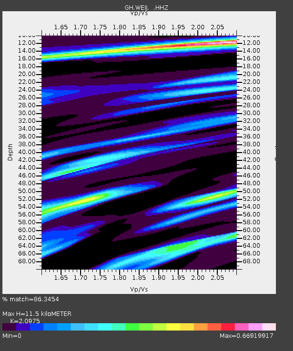
| Estimated Moho Depth: |
11.5 km |
| Estimated Crust Vp/Vs: |
2.10 |
| Assumed Crust Vp: |
6.472 km/s |
| Estimated Crust Vs: |
3.086 km/s |
| Estimated Crust Poisson's Ratio: |
0.35 |
|
| Radial Match: |
86.3454 % |
| Radial Bump: |
343 |
| Transverse Match: |
82.13505 % |
| Transverse Bump: |
400 |
| SOD ConfigId: |
626651 |
| Insert Time: |
2014-04-19 15:27:23.002 +0000 |
| GWidth: |
2.5 |
| Max Bumps: |
400 |
| Tol: |
0.001 |
|

Signal To Noise
| Channel | StoN | STA | LTA |
| GH:WEIJ: :HHZ:20131116T03:45:42.25002Z | 5.2637196 | 1.0451274E-6 | 1.9855301E-7 |
| GH:WEIJ: :HHN:20131116T03:45:42.25002Z | 1.1044987 | 3.0658316E-7 | 2.7757676E-7 |
| GH:WEIJ: :HHE:20131116T03:45:42.25002Z | 1.4424088 | 1.982459E-7 | 1.3744085E-7 |
| Arrivals |
| Ps | 2.0 SECOND |
| PpPs | 5.4 SECOND |
| PsPs/PpSs | 7.4 SECOND |


