You are here: Home > Network List > TA - USArray Transportable Network (new EarthScope stations) Stations List
> Station X59A McDuffie Farm, Elizabethtown, NC, USA > Earthquake Result Viewer
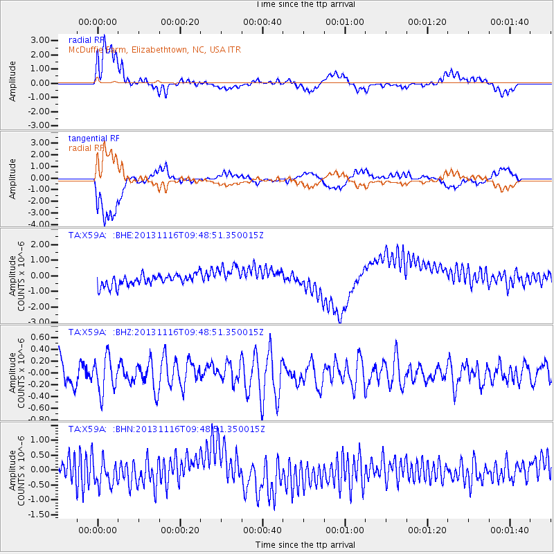
X59A McDuffie Farm, Elizabethtown, NC, USA - Earthquake Result Viewer
*The percent match for this event was below the threshold and hence no stack was calculated.
| Earthquake location: |
Scotia Sea |
| Earthquake latitude/longitude: |
-60.3/-46.4 |
| Earthquake time(UTC): |
2013/11/16 (320) 09:35:46 GMT |
| Earthquake Depth: |
10 km |
| Earthquake Magnitude: |
5.5 MWB, 5.6 MWC |
| Earthquake Catalog/Contributor: |
NEIC PDE/NEIC COMCAT |
|
| Network: |
TA USArray Transportable Network (new EarthScope stations) |
| Station: |
X59A McDuffie Farm, Elizabethtown, NC, USA |
| Lat/Lon: |
34.57 N/78.60 W |
| Elevation: |
29 m |
|
| Distance: |
98.2 deg |
| Az: |
333.646 deg |
| Baz: |
164.458 deg |
| Ray Param: |
$rayparam |
*The percent match for this event was below the threshold and hence was not used in the summary stack. |
|
| Radial Match: |
64.03142 % |
| Radial Bump: |
400 |
| Transverse Match: |
65.597565 % |
| Transverse Bump: |
400 |
| SOD ConfigId: |
626651 |
| Insert Time: |
2014-04-19 15:36:38.267 +0000 |
| GWidth: |
2.5 |
| Max Bumps: |
400 |
| Tol: |
0.001 |
|
Signal To Noise
| Channel | StoN | STA | LTA |
| TA:X59A: :BHZ:20131116T09:48:51.350015Z | 1.6763713 | 3.0435578E-7 | 1.8155629E-7 |
| TA:X59A: :BHN:20131116T09:48:51.350015Z | 1.6335882 | 5.270387E-7 | 3.226264E-7 |
| TA:X59A: :BHE:20131116T09:48:51.350015Z | 2.0290904 | 7.2211884E-7 | 3.5588303E-7 |
| Arrivals |
| Ps | |
| PpPs | |
| PsPs/PpSs | |


