You are here: Home > Network List > II - Global Seismograph Network (GSN - IRIS/IDA) Stations List
> Station NIL Nilore, Pakistan > Earthquake Result Viewer
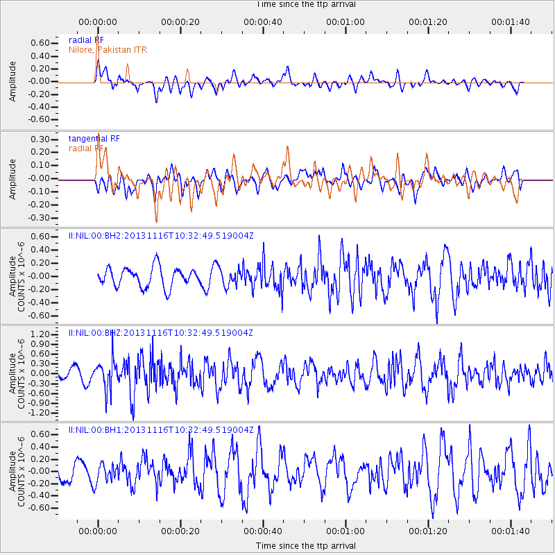
NIL Nilore, Pakistan - Earthquake Result Viewer
*The percent match for this event was below the threshold and hence no stack was calculated.
| Earthquake location: |
Off W Coast Of Northern Sumatra |
| Earthquake latitude/longitude: |
4.2/90.1 |
| Earthquake time(UTC): |
2013/11/16 (320) 10:26:43 GMT |
| Earthquake Depth: |
10 km |
| Earthquake Magnitude: |
5.7 MWB, 5.7 MWC |
| Earthquake Catalog/Contributor: |
NEIC PDE/NEIC COMCAT |
|
| Network: |
II Global Seismograph Network (GSN - IRIS/IDA) |
| Station: |
NIL Nilore, Pakistan |
| Lat/Lon: |
33.65 N/73.27 E |
| Elevation: |
629 m |
|
| Distance: |
33.2 deg |
| Az: |
333.893 deg |
| Baz: |
148.254 deg |
| Ray Param: |
$rayparam |
*The percent match for this event was below the threshold and hence was not used in the summary stack. |
|
| Radial Match: |
76.54583 % |
| Radial Bump: |
400 |
| Transverse Match: |
54.930283 % |
| Transverse Bump: |
400 |
| SOD ConfigId: |
626651 |
| Insert Time: |
2014-04-19 15:41:45.361 +0000 |
| GWidth: |
2.5 |
| Max Bumps: |
400 |
| Tol: |
0.001 |
|
Signal To Noise
| Channel | StoN | STA | LTA |
| II:NIL:00:BHZ:20131116T10:32:49.519004Z | 3.7376862 | 4.4700886E-7 | 1.1959509E-7 |
| II:NIL:00:BH1:20131116T10:32:49.519004Z | 1.0810483 | 1.4862286E-7 | 1.3748033E-7 |
| II:NIL:00:BH2:20131116T10:32:49.519004Z | 0.8672146 | 1.2348787E-7 | 1.4239596E-7 |
| Arrivals |
| Ps | |
| PpPs | |
| PsPs/PpSs | |


