You are here: Home > Network List > PF - Volcanologic Network of Piton de Fournaise-OVPF Stations List
> Station FRE Station Sismologique des Fonds de la Riviere de l'Est > Earthquake Result Viewer
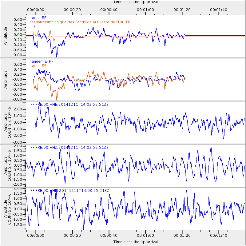
FRE Station Sismologique des Fonds de la Riviere de l'Est - Earthquake Result Viewer
*The percent match for this event was below the threshold and hence no stack was calculated.
| Earthquake location: |
South Sandwich Islands Region |
| Earthquake latitude/longitude: |
-56.9/-25.6 |
| Earthquake time(UTC): |
2014/12/11 (345) 13:53:29 GMT |
| Earthquake Depth: |
9.2 km |
| Earthquake Magnitude: |
5.7 MB |
| Earthquake Catalog/Contributor: |
NEIC PDE/NEIC COMCAT |
|
| Network: |
PF Volcanologic Network of Piton de Fournaise-OVPF |
| Station: |
FRE Station Sismologique des Fonds de la Riviere de l'Est |
| Lat/Lon: |
21.20 S/55.70 E |
| Elevation: |
1775 m |
|
| Distance: |
67.8 deg |
| Az: |
94.946 deg |
| Baz: |
215.911 deg |
| Ray Param: |
$rayparam |
*The percent match for this event was below the threshold and hence was not used in the summary stack. |
|
| Radial Match: |
49.546944 % |
| Radial Bump: |
400 |
| Transverse Match: |
51.504677 % |
| Transverse Bump: |
400 |
| SOD ConfigId: |
3390531 |
| Insert Time: |
2019-04-15 12:30:50.662 +0000 |
| GWidth: |
2.5 |
| Max Bumps: |
400 |
| Tol: |
0.001 |
|
Signal To Noise
| Channel | StoN | STA | LTA |
| PF:FRE:00:HHZ:20141211T14:03:55.513Z | 0.5957337 | 3.69731E-7 | 6.2063134E-7 |
| PF:FRE:00:HHN:20141211T14:03:55.513Z | 1.2998309 | 9.930432E-7 | 7.6397873E-7 |
| PF:FRE:00:HHE:20141211T14:03:55.513Z | 0.8633208 | 8.921826E-7 | 1.0334311E-6 |
| Arrivals |
| Ps | |
| PpPs | |
| PsPs/PpSs | |


