You are here: Home > Network List > II - Global Seismograph Network (GSN - IRIS/IDA) Stations List
> Station WRAB Tennant Creek, NT, Australia > Earthquake Result Viewer
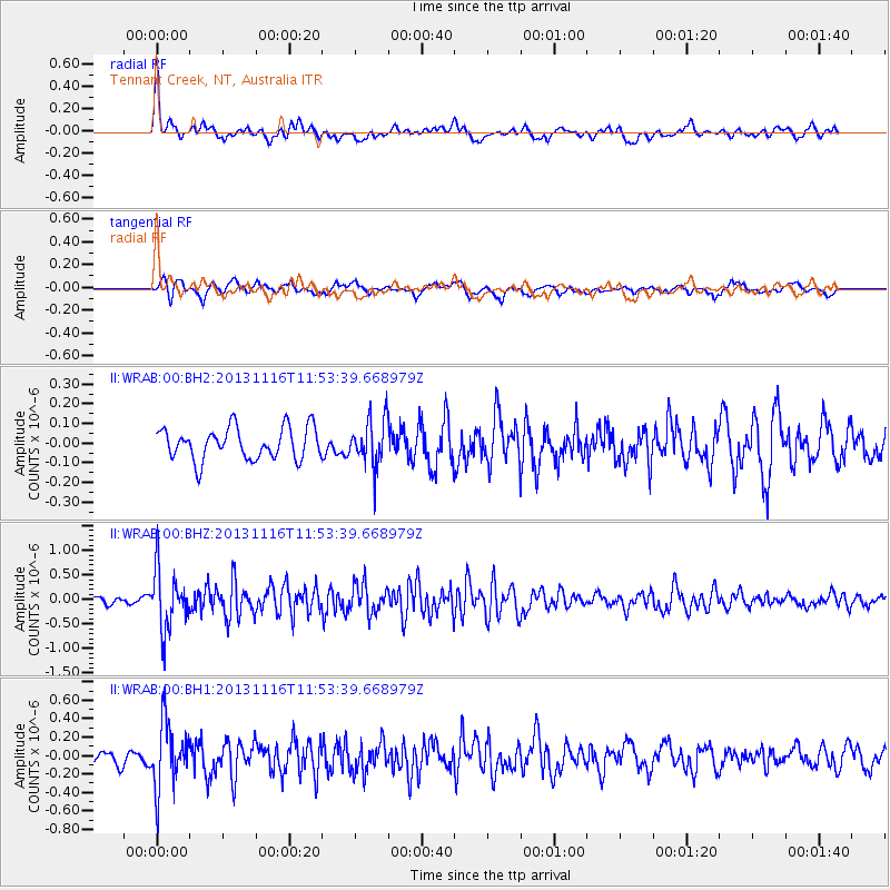
WRAB Tennant Creek, NT, Australia - Earthquake Result Viewer
*The percent match for this event was below the threshold and hence no stack was calculated.
| Earthquake location: |
Near East Coast Of Honshu, Japan |
| Earthquake latitude/longitude: |
35.6/140.2 |
| Earthquake time(UTC): |
2013/11/16 (320) 11:44:41 GMT |
| Earthquake Depth: |
59 km |
| Earthquake Magnitude: |
5.5 MWB, 5.5 MWC, 5.6 MWC |
| Earthquake Catalog/Contributor: |
NEIC PDE/NEIC COMCAT |
|
| Network: |
II Global Seismograph Network (GSN - IRIS/IDA) |
| Station: |
WRAB Tennant Creek, NT, Australia |
| Lat/Lon: |
19.93 S/134.36 E |
| Elevation: |
366 m |
|
| Distance: |
55.5 deg |
| Az: |
186.616 deg |
| Baz: |
5.728 deg |
| Ray Param: |
$rayparam |
*The percent match for this event was below the threshold and hence was not used in the summary stack. |
|
| Radial Match: |
65.84944 % |
| Radial Bump: |
391 |
| Transverse Match: |
69.39639 % |
| Transverse Bump: |
376 |
| SOD ConfigId: |
626651 |
| Insert Time: |
2014-04-19 15:59:21.784 +0000 |
| GWidth: |
2.5 |
| Max Bumps: |
400 |
| Tol: |
0.001 |
|
Signal To Noise
| Channel | StoN | STA | LTA |
| II:WRAB:00:BHZ:20131116T11:53:39.668979Z | 4.9513264 | 5.966897E-7 | 1.2051107E-7 |
| II:WRAB:00:BH1:20131116T11:53:39.668979Z | 3.4210572 | 3.5004675E-7 | 1.02321216E-7 |
| II:WRAB:00:BH2:20131116T11:53:39.668979Z | 1.4921162 | 1.20386E-7 | 8.068139E-8 |
| Arrivals |
| Ps | |
| PpPs | |
| PsPs/PpSs | |


