You are here: Home > Network List > TA - USArray Transportable Network (new EarthScope stations) Stations List
> Station L53A Girard, PA, USA > Earthquake Result Viewer
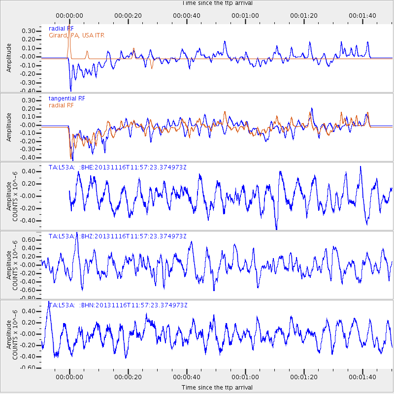
L53A Girard, PA, USA - Earthquake Result Viewer
*The percent match for this event was below the threshold and hence no stack was calculated.
| Earthquake location: |
Near East Coast Of Honshu, Japan |
| Earthquake latitude/longitude: |
35.6/140.2 |
| Earthquake time(UTC): |
2013/11/16 (320) 11:44:41 GMT |
| Earthquake Depth: |
59 km |
| Earthquake Magnitude: |
5.5 MWB, 5.5 MWC, 5.6 MWC |
| Earthquake Catalog/Contributor: |
NEIC PDE/NEIC COMCAT |
|
| Network: |
TA USArray Transportable Network (new EarthScope stations) |
| Station: |
L53A Girard, PA, USA |
| Lat/Lon: |
41.95 N/80.26 W |
| Elevation: |
355 m |
|
| Distance: |
94.4 deg |
| Az: |
29.012 deg |
| Baz: |
328.004 deg |
| Ray Param: |
$rayparam |
*The percent match for this event was below the threshold and hence was not used in the summary stack. |
|
| Radial Match: |
49.099728 % |
| Radial Bump: |
400 |
| Transverse Match: |
65.02343 % |
| Transverse Bump: |
400 |
| SOD ConfigId: |
626651 |
| Insert Time: |
2014-04-19 16:11:25.687 +0000 |
| GWidth: |
2.5 |
| Max Bumps: |
400 |
| Tol: |
0.001 |
|
Signal To Noise
| Channel | StoN | STA | LTA |
| TA:L53A: :BHZ:20131116T11:57:23.374973Z | 2.3373601 | 3.8753177E-7 | 1.6579891E-7 |
| TA:L53A: :BHN:20131116T11:57:23.374973Z | 1.0597807 | 2.7224576E-7 | 2.5688874E-7 |
| TA:L53A: :BHE:20131116T11:57:23.374973Z | 0.65788096 | 1.2055924E-7 | 1.8325387E-7 |
| Arrivals |
| Ps | |
| PpPs | |
| PsPs/PpSs | |


