You are here: Home > Network List > TA - USArray Transportable Network (new EarthScope stations) Stations List
> Station Q48A North Vernon, IN, USA > Earthquake Result Viewer
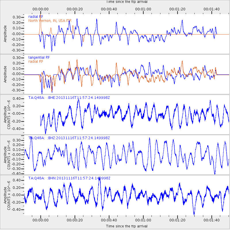
Q48A North Vernon, IN, USA - Earthquake Result Viewer
*The percent match for this event was below the threshold and hence no stack was calculated.
| Earthquake location: |
Near East Coast Of Honshu, Japan |
| Earthquake latitude/longitude: |
35.6/140.2 |
| Earthquake time(UTC): |
2013/11/16 (320) 11:44:41 GMT |
| Earthquake Depth: |
59 km |
| Earthquake Magnitude: |
5.5 MWB, 5.5 MWC, 5.6 MWC |
| Earthquake Catalog/Contributor: |
NEIC PDE/NEIC COMCAT |
|
| Network: |
TA USArray Transportable Network (new EarthScope stations) |
| Station: |
Q48A North Vernon, IN, USA |
| Lat/Lon: |
38.93 N/85.73 W |
| Elevation: |
185 m |
|
| Distance: |
94.6 deg |
| Az: |
34.178 deg |
| Baz: |
324.062 deg |
| Ray Param: |
$rayparam |
*The percent match for this event was below the threshold and hence was not used in the summary stack. |
|
| Radial Match: |
53.246925 % |
| Radial Bump: |
400 |
| Transverse Match: |
48.46841 % |
| Transverse Bump: |
400 |
| SOD ConfigId: |
626651 |
| Insert Time: |
2014-04-19 16:13:19.850 +0000 |
| GWidth: |
2.5 |
| Max Bumps: |
400 |
| Tol: |
0.001 |
|
Signal To Noise
| Channel | StoN | STA | LTA |
| TA:Q48A: :BHZ:20131116T11:57:24.149998Z | 0.5355413 | 1.18325055E-7 | 2.2094477E-7 |
| TA:Q48A: :BHN:20131116T11:57:24.149998Z | 1.5491551 | 2.0852436E-7 | 1.346052E-7 |
| TA:Q48A: :BHE:20131116T11:57:24.149998Z | 0.8771108 | 1.7044745E-7 | 1.9432831E-7 |
| Arrivals |
| Ps | |
| PpPs | |
| PsPs/PpSs | |


