You are here: Home > Network List > G - GEOSCOPE Stations List
> Station FDF Fort de France, Martinique France > Earthquake Result Viewer
FDF Fort de France, Martinique France - Earthquake Result Viewer

| Earthquake location: |
Scotia Sea |
| Earthquake latitude/longitude: |
-60.3/-46.4 |
| Earthquake time(UTC): |
2013/11/17 (321) 09:04:55 GMT |
| Earthquake Depth: |
10 km |
| Earthquake Magnitude: |
7.7 MWW, 7.6 MWC, 7.7 MWW, 7.8 MI, 7.8 MWC |
| Earthquake Catalog/Contributor: |
NEIC PDE/NEIC COMCAT |
|
| Network: |
G GEOSCOPE |
| Station: |
FDF Fort de France, Martinique France |
| Lat/Lon: |
14.73 N/61.14 W |
| Elevation: |
467 m |
|
| Distance: |
75.7 deg |
| Az: |
345.28 deg |
| Baz: |
172.48 deg |
| Ray Param: |
0.051499512 |
| Estimated Moho Depth: |
64.0 km |
| Estimated Crust Vp/Vs: |
2.07 |
| Assumed Crust Vp: |
5.88 km/s |
| Estimated Crust Vs: |
2.837 km/s |
| Estimated Crust Poisson's Ratio: |
0.35 |
|
| Radial Match: |
95.330864 % |
| Radial Bump: |
400 |
| Transverse Match: |
92.736824 % |
| Transverse Bump: |
400 |
| SOD ConfigId: |
626651 |
| Insert Time: |
2014-04-19 16:27:24.363 +0000 |
| GWidth: |
2.5 |
| Max Bumps: |
400 |
| Tol: |
0.001 |
|
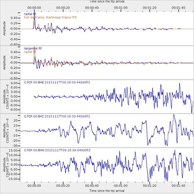
Signal To Noise
| Channel | StoN | STA | LTA |
| G:FDF:00:BHZ:20131117T09:16:09.649995Z | 4.063291 | 1.183036E-6 | 2.9115216E-7 |
| G:FDF:00:BHN:20131117T09:16:09.649995Z | 1.1548065 | 5.313181E-7 | 4.6009274E-7 |
| G:FDF:00:BHE:20131117T09:16:09.649995Z | 1.3388124 | 4.7658781E-7 | 3.5597807E-7 |
| Arrivals |
| Ps | 12 SECOND |
| PpPs | 33 SECOND |
| PsPs/PpSs | 45 SECOND |


