You are here: Home > Network List > G - GEOSCOPE Stations List
> Station TAOE Taiohae, Marquises islands > Earthquake Result Viewer
TAOE Taiohae, Marquises islands - Earthquake Result Viewer
| Earthquake location: |
Scotia Sea |
| Earthquake latitude/longitude: |
-60.3/-46.4 |
| Earthquake time(UTC): |
2013/11/17 (321) 09:04:55 GMT |
| Earthquake Depth: |
10 km |
| Earthquake Magnitude: |
7.7 MWW, 7.6 MWC, 7.7 MWW, 7.8 MI, 7.8 MWC |
| Earthquake Catalog/Contributor: |
NEIC PDE/NEIC COMCAT |
|
| Network: |
G GEOSCOPE |
| Station: |
TAOE Taiohae, Marquises islands |
| Lat/Lon: |
8.85 S/140.15 W |
| Elevation: |
800 m |
|
| Distance: |
84.2 deg |
| Az: |
262.364 deg |
| Baz: |
150.011 deg |
| Ray Param: |
0.04562477 |
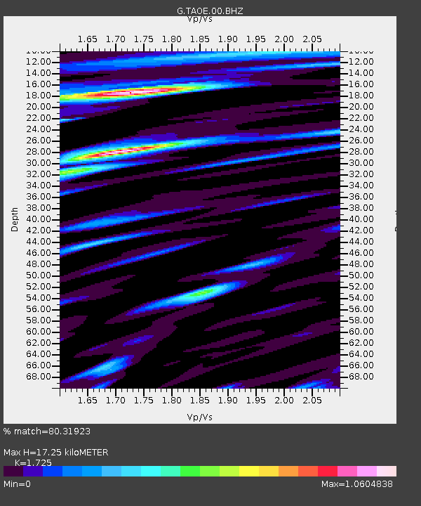
| Estimated Moho Depth: |
17.25 km |
| Estimated Crust Vp/Vs: |
1.73 |
| Assumed Crust Vp: |
4.24 km/s |
| Estimated Crust Vs: |
2.458 km/s |
| Estimated Crust Poisson's Ratio: |
0.25 |
|
| Radial Match: |
80.31923 % |
| Radial Bump: |
400 |
| Transverse Match: |
71.675964 % |
| Transverse Bump: |
400 |
| SOD ConfigId: |
626651 |
| Insert Time: |
2014-04-19 16:27:42.951 +0000 |
| GWidth: |
2.5 |
| Max Bumps: |
400 |
| Tol: |
0.001 |
|
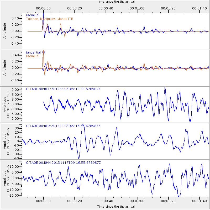
Signal To Noise
| Channel | StoN | STA | LTA |
| G:TAOE:00:BHZ:20131117T09:16:55.678987Z | 0.6646348 | 1.8501482E-6 | 2.7837063E-6 |
| G:TAOE:00:BHN:20131117T09:16:55.678987Z | 3.6409776 | 4.45443E-6 | 1.2234159E-6 |
| G:TAOE:00:BHE:20131117T09:16:55.678987Z | 0.83012545 | 1.9091158E-6 | 2.2997917E-6 |
| Arrivals |
| Ps | 3.0 SECOND |
| PpPs | 11 SECOND |
| PsPs/PpSs | 14 SECOND |


