You are here: Home > Network List > GH - Ghana Digital Seismic Network Stations List
> Station WEIJ Weija Dam, Ghana > Earthquake Result Viewer
WEIJ Weija Dam, Ghana - Earthquake Result Viewer
| Earthquake location: |
Scotia Sea |
| Earthquake latitude/longitude: |
-60.3/-46.4 |
| Earthquake time(UTC): |
2013/11/17 (321) 09:04:55 GMT |
| Earthquake Depth: |
10 km |
| Earthquake Magnitude: |
7.7 MWW, 7.6 MWC, 7.7 MWW, 7.8 MI, 7.8 MWC |
| Earthquake Catalog/Contributor: |
NEIC PDE/NEIC COMCAT |
|
| Network: |
GH Ghana Digital Seismic Network |
| Station: |
WEIJ Weija Dam, Ghana |
| Lat/Lon: |
5.59 N/0.33 W |
| Elevation: |
203 m |
|
| Distance: |
74.9 deg |
| Az: |
47.934 deg |
| Baz: |
201.822 deg |
| Ray Param: |
0.052014045 |
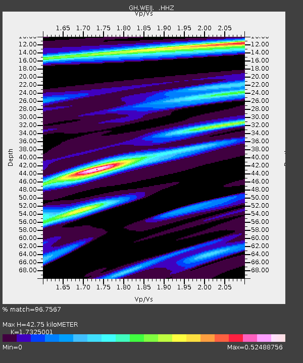
| Estimated Moho Depth: |
42.75 km |
| Estimated Crust Vp/Vs: |
1.73 |
| Assumed Crust Vp: |
6.472 km/s |
| Estimated Crust Vs: |
3.736 km/s |
| Estimated Crust Poisson's Ratio: |
0.25 |
|
| Radial Match: |
96.7567 % |
| Radial Bump: |
294 |
| Transverse Match: |
80.01556 % |
| Transverse Bump: |
400 |
| SOD ConfigId: |
626651 |
| Insert Time: |
2014-04-19 16:27:55.138 +0000 |
| GWidth: |
2.5 |
| Max Bumps: |
400 |
| Tol: |
0.001 |
|

Signal To Noise
| Channel | StoN | STA | LTA |
| GH:WEIJ: :HHZ:20131117T09:16:05.170015Z | 8.59814 | 1.2958945E-6 | 1.5071802E-7 |
| GH:WEIJ: :HHN:20131117T09:16:05.170015Z | 6.0867605 | 5.1865766E-7 | 8.521079E-8 |
| GH:WEIJ: :HHE:20131117T09:16:05.170015Z | 1.8837214 | 2.1901296E-7 | 1.16266115E-7 |
| Arrivals |
| Ps | 5.0 SECOND |
| PpPs | 17 SECOND |
| PsPs/PpSs | 22 SECOND |


