You are here: Home > Network List > CN - Canadian National Seismograph Network Stations List
> Station INK INUVIK, NT > Earthquake Result Viewer
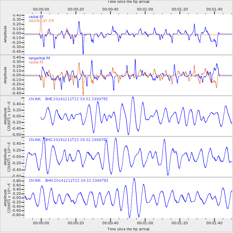
INK INUVIK, NT - Earthquake Result Viewer
*The percent match for this event was below the threshold and hence no stack was calculated.
| Earthquake location: |
Fiji Islands Region |
| Earthquake latitude/longitude: |
-20.9/-178.9 |
| Earthquake time(UTC): |
2014/12/11 (345) 22:27:45 GMT |
| Earthquake Depth: |
604 km |
| Earthquake Magnitude: |
5.7 MW, 5.0 mb |
| Earthquake Catalog/Contributor: |
ISC/ISC |
|
| Network: |
CN Canadian National Seismograph Network |
| Station: |
INK INUVIK, NT |
| Lat/Lon: |
68.31 N/133.53 W |
| Elevation: |
44 m |
|
| Distance: |
94.9 deg |
| Az: |
15.404 deg |
| Baz: |
221.901 deg |
| Ray Param: |
$rayparam |
*The percent match for this event was below the threshold and hence was not used in the summary stack. |
|
| Radial Match: |
67.14028 % |
| Radial Bump: |
400 |
| Transverse Match: |
64.19936 % |
| Transverse Bump: |
400 |
| SOD ConfigId: |
3390531 |
| Insert Time: |
2019-04-15 12:40:52.167 +0000 |
| GWidth: |
2.5 |
| Max Bumps: |
400 |
| Tol: |
0.001 |
|
Signal To Noise
| Channel | StoN | STA | LTA |
| CN:INK: :BHZ:20141211T22:39:32.299978Z | 1.3232507 | 3.7944687E-7 | 2.867536E-7 |
| CN:INK: :BHN:20141211T22:39:32.299978Z | 3.9810972 | 3.8755644E-7 | 9.734915E-8 |
| CN:INK: :BHE:20141211T22:39:32.299978Z | 2.5349715 | 3.3131843E-7 | 1.3069908E-7 |
| Arrivals |
| Ps | |
| PpPs | |
| PsPs/PpSs | |


