You are here: Home > Network List > II - Global Seismograph Network (GSN - IRIS/IDA) Stations List
> Station ABPO Ambohimpanompo, Madagascar > Earthquake Result Viewer
ABPO Ambohimpanompo, Madagascar - Earthquake Result Viewer
| Earthquake location: |
Scotia Sea |
| Earthquake latitude/longitude: |
-60.3/-46.4 |
| Earthquake time(UTC): |
2013/11/17 (321) 09:04:55 GMT |
| Earthquake Depth: |
10 km |
| Earthquake Magnitude: |
7.7 MWW, 7.6 MWC, 7.7 MWW, 7.8 MI, 7.8 MWC |
| Earthquake Catalog/Contributor: |
NEIC PDE/NEIC COMCAT |
|
| Network: |
II Global Seismograph Network (GSN - IRIS/IDA) |
| Station: |
ABPO Ambohimpanompo, Madagascar |
| Lat/Lon: |
19.02 S/47.23 E |
| Elevation: |
1528 m |
|
| Distance: |
75.5 deg |
| Az: |
102.733 deg |
| Baz: |
210.918 deg |
| Ray Param: |
0.051650792 |
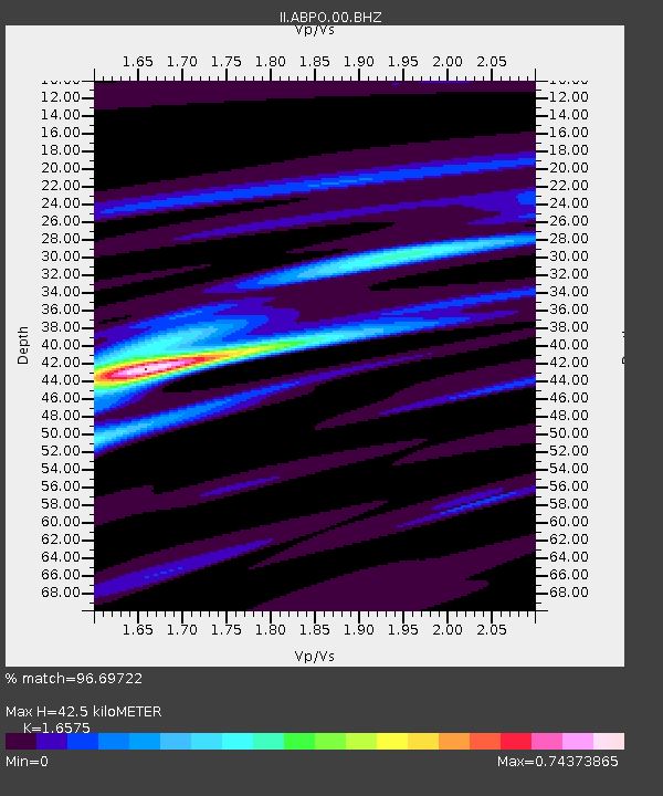
| Estimated Moho Depth: |
42.5 km |
| Estimated Crust Vp/Vs: |
1.66 |
| Assumed Crust Vp: |
6.642 km/s |
| Estimated Crust Vs: |
4.007 km/s |
| Estimated Crust Poisson's Ratio: |
0.21 |
|
| Radial Match: |
96.69722 % |
| Radial Bump: |
240 |
| Transverse Match: |
89.527374 % |
| Transverse Bump: |
400 |
| SOD ConfigId: |
626651 |
| Insert Time: |
2014-04-19 16:28:21.754 +0000 |
| GWidth: |
2.5 |
| Max Bumps: |
400 |
| Tol: |
0.001 |
|
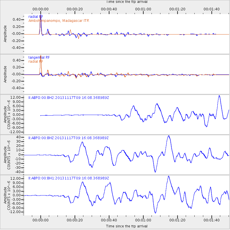
Signal To Noise
| Channel | StoN | STA | LTA |
| II:ABPO:00:BHZ:20131117T09:16:08.368989Z | 2.1541908 | 4.4441316E-7 | 2.0630166E-7 |
| II:ABPO:00:BH1:20131117T09:16:08.368989Z | 2.0282214 | 2.2758931E-7 | 1.12211275E-7 |
| II:ABPO:00:BH2:20131117T09:16:08.368989Z | 1.3294894 | 1.9392114E-7 | 1.4586138E-7 |
| Arrivals |
| Ps | 4.4 SECOND |
| PpPs | 16 SECOND |
| PsPs/PpSs | 21 SECOND |


