You are here: Home > Network List > IU - Global Seismograph Network (GSN - IRIS/USGS) Stations List
> Station SNZO South Karori, New Zealand > Earthquake Result Viewer
SNZO South Karori, New Zealand - Earthquake Result Viewer
| Earthquake location: |
Scotia Sea |
| Earthquake latitude/longitude: |
-60.3/-46.4 |
| Earthquake time(UTC): |
2013/11/17 (321) 09:04:55 GMT |
| Earthquake Depth: |
10 km |
| Earthquake Magnitude: |
7.7 MWW, 7.6 MWC, 7.7 MWW, 7.8 MI, 7.8 MWC |
| Earthquake Catalog/Contributor: |
NEIC PDE/NEIC COMCAT |
|
| Network: |
IU Global Seismograph Network (GSN - IRIS/USGS) |
| Station: |
SNZO South Karori, New Zealand |
| Lat/Lon: |
41.31 S/174.70 E |
| Elevation: |
120 m |
|
| Distance: |
73.3 deg |
| Az: |
211.137 deg |
| Baz: |
159.997 deg |
| Ray Param: |
0.053089753 |
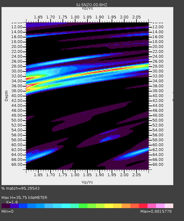
| Estimated Moho Depth: |
35.75 km |
| Estimated Crust Vp/Vs: |
1.60 |
| Assumed Crust Vp: |
6.461 km/s |
| Estimated Crust Vs: |
4.038 km/s |
| Estimated Crust Poisson's Ratio: |
0.18 |
|
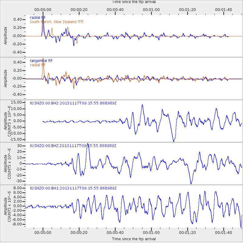
| Radial Match: |
95.29543 % |
| Radial Bump: |
331 |
| Transverse Match: |
87.72085 % |
| Transverse Bump: |
400 |
| SOD ConfigId: |
626651 |
| Insert Time: |
2014-04-19 16:29:05.723 +0000 |
| GWidth: |
2.5 |
| Max Bumps: |
400 |
| Tol: |
0.001 |
|
Signal To Noise
| Channel | StoN | STA | LTA |
| IU:SNZO:00:BHZ:20131117T09:15:55.868989Z | 2.6263475 | 8.564498E-7 | 3.2609918E-7 |
| IU:SNZO:00:BH1:20131117T09:15:55.868989Z | 0.55812544 | 2.1381082E-7 | 3.8308738E-7 |
| IU:SNZO:00:BH2:20131117T09:15:55.868989Z | 1.5580797 | 6.4774576E-7 | 4.1573338E-7 |
| Arrivals |
| Ps | 3.4 SECOND |
| PpPs | 14 SECOND |
| PsPs/PpSs | 17 SECOND |


