You are here: Home > Network List > TA - USArray Transportable Network (new EarthScope stations) Stations List
> Station X59A McDuffie Farm, Elizabethtown, NC, USA > Earthquake Result Viewer
X59A McDuffie Farm, Elizabethtown, NC, USA - Earthquake Result Viewer
| Earthquake location: |
Scotia Sea |
| Earthquake latitude/longitude: |
-60.3/-46.4 |
| Earthquake time(UTC): |
2013/11/17 (321) 09:04:55 GMT |
| Earthquake Depth: |
10 km |
| Earthquake Magnitude: |
7.7 MWW, 7.6 MWC, 7.7 MWW, 7.8 MI, 7.8 MWC |
| Earthquake Catalog/Contributor: |
NEIC PDE/NEIC COMCAT |
|
| Network: |
TA USArray Transportable Network (new EarthScope stations) |
| Station: |
X59A McDuffie Farm, Elizabethtown, NC, USA |
| Lat/Lon: |
34.57 N/78.60 W |
| Elevation: |
29 m |
|
| Distance: |
98.1 deg |
| Az: |
333.626 deg |
| Baz: |
164.438 deg |
| Ray Param: |
0.03999375 |
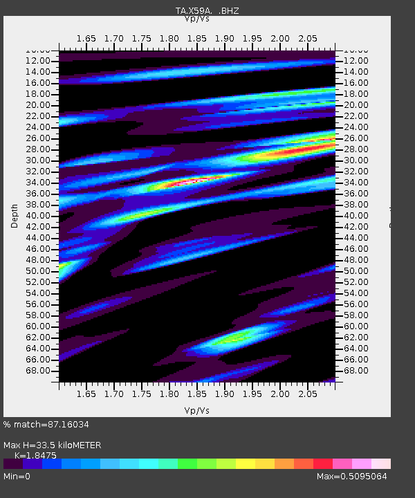
| Estimated Moho Depth: |
33.5 km |
| Estimated Crust Vp/Vs: |
1.85 |
| Assumed Crust Vp: |
6.565 km/s |
| Estimated Crust Vs: |
3.553 km/s |
| Estimated Crust Poisson's Ratio: |
0.29 |
|
| Radial Match: |
87.16034 % |
| Radial Bump: |
400 |
| Transverse Match: |
58.696262 % |
| Transverse Bump: |
400 |
| SOD ConfigId: |
626651 |
| Insert Time: |
2014-04-19 16:31:58.607 +0000 |
| GWidth: |
2.5 |
| Max Bumps: |
400 |
| Tol: |
0.001 |
|
Signal To Noise
| Channel | StoN | STA | LTA |
| TA:X59A: :BHZ:20131117T09:18:00.649995Z | 1.3195016 | 2.6774435E-7 | 2.0291324E-7 |
| TA:X59A: :BHN:20131117T09:18:00.649995Z | 0.65907735 | 1.9598501E-7 | 2.9736267E-7 |
| TA:X59A: :BHE:20131117T09:18:00.649995Z | 0.93274724 | 3.1293848E-7 | 3.355019E-7 |
| Arrivals |
| Ps | 4.4 SECOND |
| PpPs | 14 SECOND |
| PsPs/PpSs | 19 SECOND |


