You are here: Home > Network List > TA - USArray Transportable Network (new EarthScope stations) Stations List
> Station Y55A Saluda, SC, USA > Earthquake Result Viewer
Y55A Saluda, SC, USA - Earthquake Result Viewer
| Earthquake location: |
Scotia Sea |
| Earthquake latitude/longitude: |
-60.3/-46.4 |
| Earthquake time(UTC): |
2013/11/17 (321) 09:04:55 GMT |
| Earthquake Depth: |
10 km |
| Earthquake Magnitude: |
7.7 MWW, 7.6 MWC, 7.7 MWW, 7.8 MI, 7.8 MWC |
| Earthquake Catalog/Contributor: |
NEIC PDE/NEIC COMCAT |
|
| Network: |
TA USArray Transportable Network (new EarthScope stations) |
| Station: |
Y55A Saluda, SC, USA |
| Lat/Lon: |
33.94 N/81.86 W |
| Elevation: |
164 m |
|
| Distance: |
98.3 deg |
| Az: |
330.832 deg |
| Baz: |
163.013 deg |
| Ray Param: |
0.03994649 |
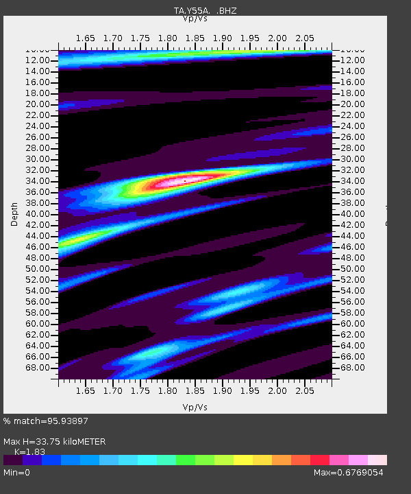
| Estimated Moho Depth: |
33.75 km |
| Estimated Crust Vp/Vs: |
1.83 |
| Assumed Crust Vp: |
6.565 km/s |
| Estimated Crust Vs: |
3.587 km/s |
| Estimated Crust Poisson's Ratio: |
0.29 |
|
| Radial Match: |
95.93897 % |
| Radial Bump: |
400 |
| Transverse Match: |
58.05369 % |
| Transverse Bump: |
400 |
| SOD ConfigId: |
626651 |
| Insert Time: |
2014-04-19 16:32:03.766 +0000 |
| GWidth: |
2.5 |
| Max Bumps: |
400 |
| Tol: |
0.001 |
|

Signal To Noise
| Channel | StoN | STA | LTA |
| TA:Y55A: :BHZ:20131117T09:18:01.324983Z | 2.5051851 | 2.6853388E-7 | 1.0719123E-7 |
| TA:Y55A: :BHN:20131117T09:18:01.324983Z | 0.72213423 | 7.375984E-8 | 1.0214146E-7 |
| TA:Y55A: :BHE:20131117T09:18:01.324983Z | 1.6817014 | 1.8015702E-7 | 1.07127825E-7 |
| Arrivals |
| Ps | 4.4 SECOND |
| PpPs | 14 SECOND |
| PsPs/PpSs | 19 SECOND |


