You are here: Home > Network List > LD - Lamont-Doherty Cooperative Seismographic Network Stations List
> Station LUPA Lehigh University, PA > Earthquake Result Viewer
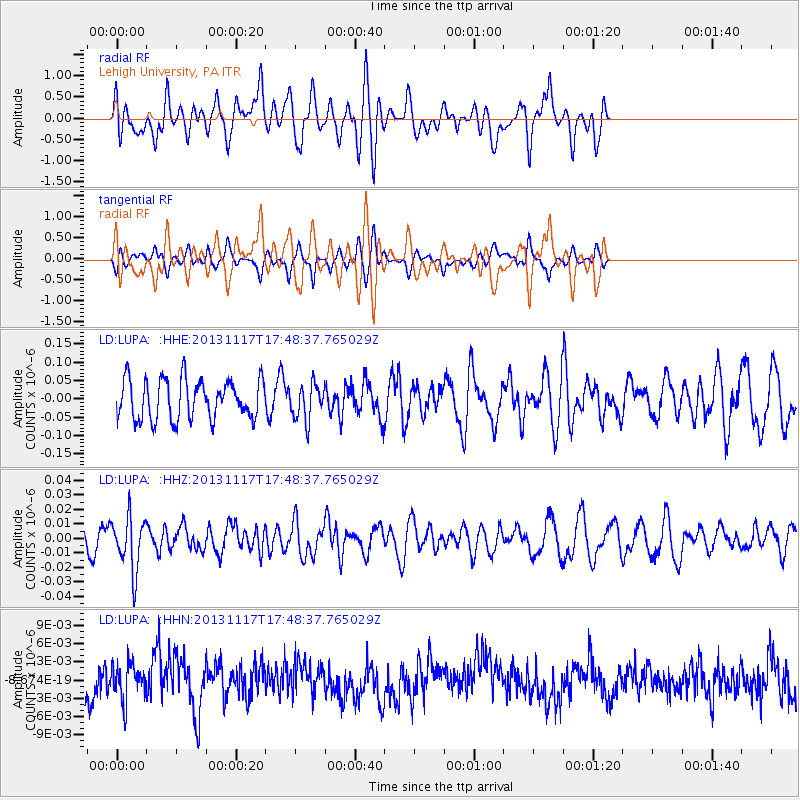
LUPA Lehigh University, PA - Earthquake Result Viewer
*The percent match for this event was below the threshold and hence no stack was calculated.
| Earthquake location: |
Ascension Island Region |
| Earthquake latitude/longitude: |
-10.3/-11.8 |
| Earthquake time(UTC): |
2013/11/17 (321) 17:37:14 GMT |
| Earthquake Depth: |
10 km |
| Earthquake Magnitude: |
5.5 MB, 5.4 MWC |
| Earthquake Catalog/Contributor: |
NEIC PDE/NEIC COMCAT |
|
| Network: |
LD Lamont-Doherty Cooperative Seismographic Network |
| Station: |
LUPA Lehigh University, PA |
| Lat/Lon: |
40.60 N/75.37 W |
| Elevation: |
236 m |
|
| Distance: |
77.4 deg |
| Az: |
315.691 deg |
| Baz: |
115.485 deg |
| Ray Param: |
$rayparam |
*The percent match for this event was below the threshold and hence was not used in the summary stack. |
|
| Radial Match: |
50.961567 % |
| Radial Bump: |
389 |
| Transverse Match: |
50.315666 % |
| Transverse Bump: |
335 |
| SOD ConfigId: |
626651 |
| Insert Time: |
2014-04-19 16:50:05.471 +0000 |
| GWidth: |
2.5 |
| Max Bumps: |
400 |
| Tol: |
0.001 |
|
Signal To Noise
| Channel | StoN | STA | LTA |
| LD:LUPA: :HHZ:20131117T17:48:37.765029Z | 2.5869205 | 1.844214E-8 | 7.1289934E-9 |
| LD:LUPA: :HHN:20131117T17:48:37.765029Z | 0.955941 | 2.9255183E-9 | 3.0603544E-9 |
| LD:LUPA: :HHE:20131117T17:48:37.765029Z | 0.9040312 | 4.8719116E-8 | 5.3890965E-8 |
| Arrivals |
| Ps | |
| PpPs | |
| PsPs/PpSs | |


