You are here: Home > Network List > TA - USArray Transportable Network (new EarthScope stations) Stations List
> Station 155A Kite, GA, USA > Earthquake Result Viewer
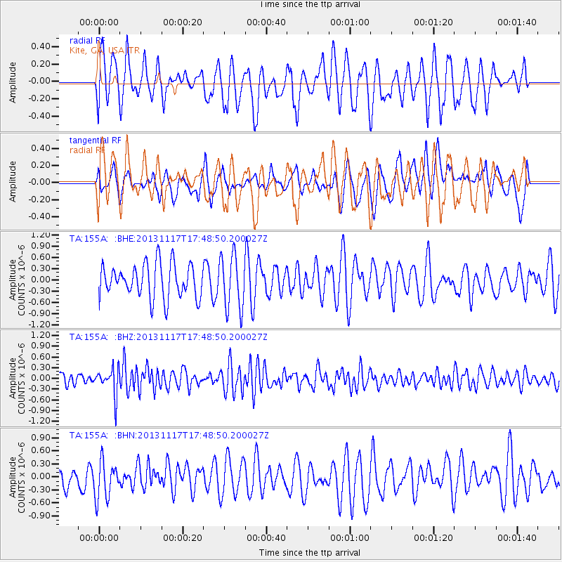
155A Kite, GA, USA - Earthquake Result Viewer
*The percent match for this event was below the threshold and hence no stack was calculated.
| Earthquake location: |
Ascension Island Region |
| Earthquake latitude/longitude: |
-10.3/-11.8 |
| Earthquake time(UTC): |
2013/11/17 (321) 17:37:14 GMT |
| Earthquake Depth: |
10 km |
| Earthquake Magnitude: |
5.5 MB, 5.4 MWC |
| Earthquake Catalog/Contributor: |
NEIC PDE/NEIC COMCAT |
|
| Network: |
TA USArray Transportable Network (new EarthScope stations) |
| Station: |
155A Kite, GA, USA |
| Lat/Lon: |
32.62 N/82.47 W |
| Elevation: |
93 m |
|
| Distance: |
79.6 deg |
| Az: |
305.971 deg |
| Baz: |
109.317 deg |
| Ray Param: |
$rayparam |
*The percent match for this event was below the threshold and hence was not used in the summary stack. |
|
| Radial Match: |
47.56292 % |
| Radial Bump: |
400 |
| Transverse Match: |
56.10254 % |
| Transverse Bump: |
400 |
| SOD ConfigId: |
626651 |
| Insert Time: |
2014-04-19 16:53:34.656 +0000 |
| GWidth: |
2.5 |
| Max Bumps: |
400 |
| Tol: |
0.001 |
|
Signal To Noise
| Channel | StoN | STA | LTA |
| TA:155A: :BHZ:20131117T17:48:50.200027Z | 2.2926528 | 3.8517155E-7 | 1.6800256E-7 |
| TA:155A: :BHN:20131117T17:48:50.200027Z | 1.2564617 | 4.4430638E-7 | 3.536171E-7 |
| TA:155A: :BHE:20131117T17:48:50.200027Z | 1.6357461 | 7.2946193E-7 | 4.4595058E-7 |
| Arrivals |
| Ps | |
| PpPs | |
| PsPs/PpSs | |


