You are here: Home > Network List > TA - USArray Transportable Network (new EarthScope stations) Stations List
> Station 435B Jarrell, TX, USA > Earthquake Result Viewer
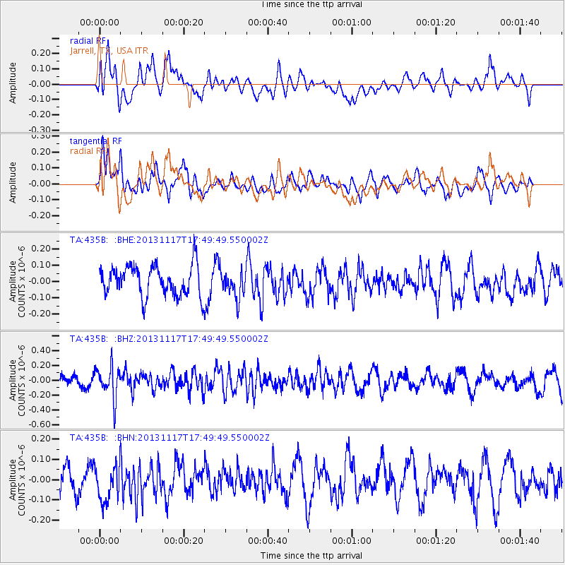
435B Jarrell, TX, USA - Earthquake Result Viewer
*The percent match for this event was below the threshold and hence no stack was calculated.
| Earthquake location: |
Ascension Island Region |
| Earthquake latitude/longitude: |
-10.3/-11.8 |
| Earthquake time(UTC): |
2013/11/17 (321) 17:37:14 GMT |
| Earthquake Depth: |
10 km |
| Earthquake Magnitude: |
5.5 MB, 5.4 MWC |
| Earthquake Catalog/Contributor: |
NEIC PDE/NEIC COMCAT |
|
| Network: |
TA USArray Transportable Network (new EarthScope stations) |
| Station: |
435B Jarrell, TX, USA |
| Lat/Lon: |
30.78 N/97.58 W |
| Elevation: |
248 m |
|
| Distance: |
91.6 deg |
| Az: |
300.841 deg |
| Baz: |
100.983 deg |
| Ray Param: |
$rayparam |
*The percent match for this event was below the threshold and hence was not used in the summary stack. |
|
| Radial Match: |
53.983265 % |
| Radial Bump: |
400 |
| Transverse Match: |
54.948948 % |
| Transverse Bump: |
400 |
| SOD ConfigId: |
626651 |
| Insert Time: |
2014-04-19 16:53:53.506 +0000 |
| GWidth: |
2.5 |
| Max Bumps: |
400 |
| Tol: |
0.001 |
|
Signal To Noise
| Channel | StoN | STA | LTA |
| TA:435B: :BHZ:20131117T17:49:49.550002Z | 2.0833063 | 2.2076175E-7 | 1.0596701E-7 |
| TA:435B: :BHN:20131117T17:49:49.550002Z | 1.2938973 | 9.073079E-8 | 7.0122105E-8 |
| TA:435B: :BHE:20131117T17:49:49.550002Z | 0.9109739 | 8.408947E-8 | 9.2307225E-8 |
| Arrivals |
| Ps | |
| PpPs | |
| PsPs/PpSs | |


