You are here: Home > Network List > TA - USArray Transportable Network (new EarthScope stations) Stations List
> Station L54A Sinclairville, NY, USA > Earthquake Result Viewer
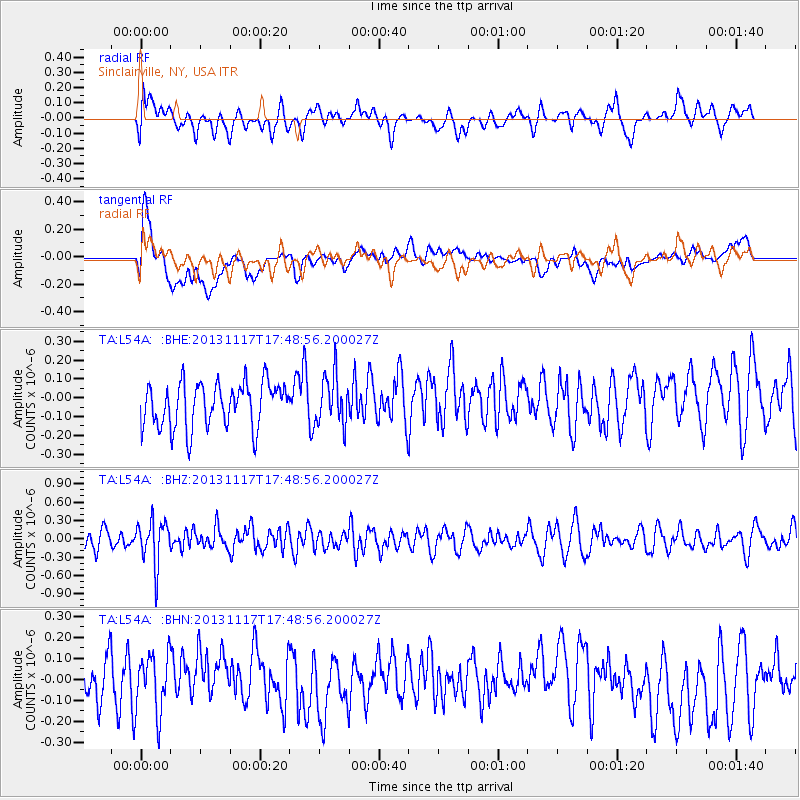
L54A Sinclairville, NY, USA - Earthquake Result Viewer
*The percent match for this event was below the threshold and hence no stack was calculated.
| Earthquake location: |
Ascension Island Region |
| Earthquake latitude/longitude: |
-10.3/-11.8 |
| Earthquake time(UTC): |
2013/11/17 (321) 17:37:14 GMT |
| Earthquake Depth: |
10 km |
| Earthquake Magnitude: |
5.5 MB, 5.4 MWC |
| Earthquake Catalog/Contributor: |
NEIC PDE/NEIC COMCAT |
|
| Network: |
TA USArray Transportable Network (new EarthScope stations) |
| Station: |
L54A Sinclairville, NY, USA |
| Lat/Lon: |
42.23 N/79.32 W |
| Elevation: |
432 m |
|
| Distance: |
80.8 deg |
| Az: |
315.97 deg |
| Baz: |
112.937 deg |
| Ray Param: |
$rayparam |
*The percent match for this event was below the threshold and hence was not used in the summary stack. |
|
| Radial Match: |
49.55401 % |
| Radial Bump: |
400 |
| Transverse Match: |
62.934162 % |
| Transverse Bump: |
400 |
| SOD ConfigId: |
626651 |
| Insert Time: |
2014-04-19 16:57:39.203 +0000 |
| GWidth: |
2.5 |
| Max Bumps: |
400 |
| Tol: |
0.001 |
|
Signal To Noise
| Channel | StoN | STA | LTA |
| TA:L54A: :BHZ:20131117T17:48:56.200027Z | 2.1294074 | 3.6126593E-7 | 1.6965562E-7 |
| TA:L54A: :BHN:20131117T17:48:56.200027Z | 1.1036384 | 1.437979E-7 | 1.302944E-7 |
| TA:L54A: :BHE:20131117T17:48:56.200027Z | 1.1167048 | 1.3278924E-7 | 1.18911686E-7 |
| Arrivals |
| Ps | |
| PpPs | |
| PsPs/PpSs | |


