You are here: Home > Network List > TA - USArray Transportable Network (new EarthScope stations) Stations List
> Station S44A Carbondale, IL, USA > Earthquake Result Viewer
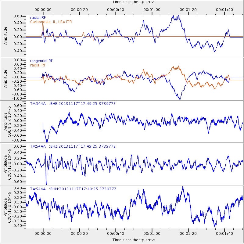
S44A Carbondale, IL, USA - Earthquake Result Viewer
*The percent match for this event was below the threshold and hence no stack was calculated.
| Earthquake location: |
Ascension Island Region |
| Earthquake latitude/longitude: |
-10.3/-11.8 |
| Earthquake time(UTC): |
2013/11/17 (321) 17:37:14 GMT |
| Earthquake Depth: |
10 km |
| Earthquake Magnitude: |
5.5 MB, 5.4 MWC |
| Earthquake Catalog/Contributor: |
NEIC PDE/NEIC COMCAT |
|
| Network: |
TA USArray Transportable Network (new EarthScope stations) |
| Station: |
S44A Carbondale, IL, USA |
| Lat/Lon: |
37.69 N/89.26 W |
| Elevation: |
155 m |
|
| Distance: |
86.5 deg |
| Az: |
309.131 deg |
| Baz: |
105.802 deg |
| Ray Param: |
$rayparam |
*The percent match for this event was below the threshold and hence was not used in the summary stack. |
|
| Radial Match: |
42.90113 % |
| Radial Bump: |
400 |
| Transverse Match: |
39.465214 % |
| Transverse Bump: |
400 |
| SOD ConfigId: |
626651 |
| Insert Time: |
2014-04-19 17:00:22.894 +0000 |
| GWidth: |
2.5 |
| Max Bumps: |
400 |
| Tol: |
0.001 |
|
Signal To Noise
| Channel | StoN | STA | LTA |
| TA:S44A: :BHZ:20131117T17:49:25.373977Z | 2.9683132 | 2.432314E-7 | 8.194264E-8 |
| TA:S44A: :BHN:20131117T17:49:25.373977Z | 0.46399945 | 1.1437436E-7 | 2.4649677E-7 |
| TA:S44A: :BHE:20131117T17:49:25.373977Z | 0.6740754 | 1.8284794E-7 | 2.712574E-7 |
| Arrivals |
| Ps | |
| PpPs | |
| PsPs/PpSs | |


